Could the solution be under the city itself in the vast and ancient irrigation networks of the Hohokam people?
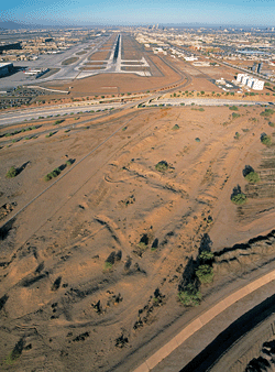
The city of Phoenix was built on the ruins of a Hohokam settlement that is between 1,500 and 550 years old. The remains of a canal network are still visible near the airport.
(Adriel Heisey)
At a time when water is still relatively inexpensive and abundant, at least in the industrialized world, it is easy to forget that controlling water was a necessary first step to feed and quench the thirst of the people who built the first cities. Brian Fagan's soon-to-be-released book Elixir: A History of Water and Humankind, provides an in-depth examination of the history of water control. For thousands of years, societies have found inventive ways to provide water for their fields and their people in spite of fickle climates. It is no exaggeration to say that civilization itself is built on a foundation of water. This excerpt from Fagan's book centers on the Hohokam people, who used an elaborate network of canals to support a society that flourished in the area around Phoenix, Arizona, until about 550 years ago.
October 2008. The propjet's engine slowed and I woke abruptly, watching an almost surreal urban landscape come into view as we descended. The sun was setting behind us, casting long shadows, but Phoenix shimmered beneath us. Broad streets led into the far distance, and huddled apartment buildings and carefully ordered subdivisions were scattered over arid terrain. High-rise office buildings towered incongruously over the desert. Everything was yellow or buff-colored except for occasional splashes of green—golf courses, parks, and irrigated farms seemed to have sprung up without notice from the dry landscape. Dozens of blue swimming pools adorned suburban yards. Over to the left, the long, straight line of an aqueduct ran to the distant horizon.
All of this urban sprawl depends on finite water supplies pumped from deep beneath the earth or delivered from afar. Coming from a California in the midst of a multiyear drought, I wondered just how long it would be before promiscuously expanding Phoenix imploded in the face of chronic water shortages triggered in part by a culture of urban excess and waste.
The statistics are daunting: More than 1.8 million people live in Phoenix itself, and a further 22 cities surround it in the Valley of the Sun, forming the largest metropolitan landscape by area in the United States. Each year the valley receives about seven inches of rainfall. Average temperatures exceed 100 degrees for three months a year, with peaks as high as 120 degrees.
We descended gradually, bumping gently in the late afternoon turbulence, and passed over the meandering Salt River, its waters yellow-brown in the hazy sunlight. Once this was the land of the Huhugam, meaning "something that is all gone" in the O'odham language. To archaeologists they are known as the Hohokam, an ancient people who faced the challenges of this dry and changeable environment for more than a thousand years and turned this inhospitable desert into a thriving urban and agricultural landscape. In some ways the story of the Hohokam offers an example of how to live sustainably in this landscape, but it also reveals what a difficult balancing act it is.
Phoenix and its surrounding communities have paved over much of the Hohokam world. But the long-vanished farmers reappear with persistent frequency, under the foundations of modern buildings razed for new development, in the pathways of expanding interstates, even in backyard gardens. For the most part, the traces of their presence are inconspicuous, requiring careful dissection with spade and trowel. Only a few notable adobe structures still stand above ground, making it hard to believe that the Salt River Valley was the most populous and agriculturally productive valley in the Southwest before A.D. 1500. The land looks barren and utterly dry, yet it has fertile soils and lies near major river drainages. Between A.D. 450 and 1500, the Hohokam living near the Salt River adapted brilliantly to this seemingly desolate environment, refining their agriculture and water management from one generation to the next. Over more than 10 centuries, they built vast canal networks up to 22 miles long and irrigated tracts of arid land up to 70,000 acres in size.
Archaeologists identify the Hohokam from their buff- to brown-colored potsherds that abound in the river basin floors of southern Arizona. If we use such vessels as a criterion, then we can trace the extent of the Hohokam over more than 30,000 square miles of southern Arizona—an area larger than South Carolina. In general terms, Hohokam groups shared a common ingenuity as farmers, a superb ability at irrigation agriculture, and a common architecture of adobe dwellings. There were none of the elaborate, multistory pueblos of Chaco Canyon and Mesa Verde here, but a distinctive ceremonial architecture based on adobe platform mounds and ball courts, the latter apparently an import from Mexico.
Hohokam canals flow outward from the Salt River like the tentacles of a giant octopus. They split and split again, once full of gently flowing water transported for mile after mile by the forces of gravity. Omar Turney, a city engineer for Phoenix, mapped the ancient Hohokam irrigation systems during the 1920s. He walked over the river basin and consulted old maps and historical records to reveal what he called "the largest single body of land irrigated in prehistoric times in North or South America." The lower Salt River Valley, where downtown Phoenix now stands, supported miles of irrigated fields and dozens of farming communities. The scale of the irrigation works boggles the imagination. In the downtown metropolitan area alone, 300 miles of canals formed 14 irrigation networks that watered 256,000 acres of fertile river basin soils. The Gila River Valley to the south, with its four irrigation networks, watered nearly 19,000 acres of closely packed fields a thousand years ago. In the heart of this carefully engineered landscape, stood the 250-acre Snaketown site, with its ceremonial ball court. Six miles of irrigated land and smaller settlements lay along the river upstream and downstream of Snaketown. The dense cultivation extended as much as two miles from the riverbanks.
The Gila and Salt rivers received their water from highland watersheds. The river flow varied from season to season and year to year, but provided generally reliable water supplies for the Hohokam's fields. Away from the great rivers, farmers relied on both summer and winter rainfall. They would trap the occasional tributary flood, use terraces and small dams to trap water, and place their crops with meticulous care to avoid extremes of heat or cold. There was nothing the Hohokam did not know about farming in arid landscapes, and they supplemented their crops by hunting and gathering plant foods.
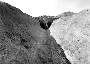
Archaeologist Emil Haury, who originally excavated the site of Snaketown in 1934 and 1935, returned again in 1964 and 1965, and is shown standing at the intersection of two of the site's canals.
(Courtesy Helga Teiwes, Arizona State Museum)
The canal systems began at the river, where a weir raised the water level and directed it into the canal. A head gate regulated the amount of water passing into the system. From there, the water flowed along large distribution canals that were up to 85 feet across and 20 feet deep. The size of the canal diminished away from the river, a technique that ensured an even water flow. A steady flow ensured that too rapid a current did not erode the earthen sides. If, however, the current was too slow, it would deposit silt and clog the defile. Control gates lay at intervals along the main canals. When closed, they caused the current to back up, creating a head of water and allowing the farmers to regulate the flow down-canal. Feeder channels carried water through wicker and stone gates along long branches of the main canals, in turn leading to much smaller defiles that fed gridlike field systems, each with their own water supplies constrained within banks like a crowded chess board.
The amount of communal labor required to construct and maintain these irrigation works was enormous. Reconstructions of ancient canals suggest that as much as 28.25 million cubic feet of dirt may have been excavated to construct one major canal system alone. If a single worker removed 106 cubic feet of soil a day, it would have taken more than 25,000 person-days to build many of the canals.
Hohokam culture as archaeologists know it appeared around A.D. 500, at the moment when the plazas were first built, at a time when new pottery forms came into being and improvements in grinding technology made food preparation somewhat easier. More diverse cooking vessels allowed mothers to wean their children earlier and feed them soft foods. At this time new varieties of maize also appeared in Hohokam fields.
Phoenix's Sky Harbor Airport lies on the Salt River floodplain. When archaeologists surveyed the land under the runways and airport buildings, they found extensive tracts of once-irrigated land and large and small houses built alongside the fields. Here, people camped during the growing season. The larger structures with hearths were the places where farmers cooked and slept, the smaller ones used for storage and other purposes. These were casual, temporary structures, rebuilt again and again over the centuries. But this very rebuilding confirms that the same households farmed the same plots of land over many generations.
Early permanent villages founded along the Gila and Salt rivers coincide with the construction of the first large-scale canal system. If the O'odham people, who followed the Hohokam in this area, are any guide, those who participated in canal construction had the first pick of the best land. Later arrivals would have occupied less desirable acreage. Over time, the first comers, who enjoyed the best access to prime irrigated land, would have acquired wealth and status, in part because of their more productive fields. In later times, Hohokam communities varied greatly in size. Some, like those on the Gila River south of Phoenix, ranged along single canals that lay parallel to the river on either bank. Such communities may have covered 15 square miles and contained as many as 2,550 irrigated acres. Salt River communities lived amid branching canal networks that traversed the Phoenix Basin. Suzanne Fish, who has studied Basin communities of A.D. 1100 and later, estimates that community territories averaged 15 square miles, a figure similar to that from the Gila.
The household lay at the core of Hohokam irrigation works and of society as a whole. Their members built and maintained a sophisticated canal network. They provided the demanding labor needed to sustain an intensive agricultural regimen for nearly a thousand years. How did this system work, with all the close cooperation that it required? Judging from historical practice among the O'odham, individual households held claims to plots of land that passed from one generation to the next. However, rights to irrigation water belonged to the community as a whole, the water being allocated to each household according to the amount of land they cultivated. Households shared water rights. Thus, they had an interest in protecting these rights and protecting their investment in the canal works that brought water to their fields.
Some archaeologists believe that there must have been a dynamic tension between individual interests of the households and collective ones. The two tension points were always in play, balancing one another out over years, generations, and centuries. The resulting balance enhanced the long-term stability of a society that depended heavily on canals to bring water to soils that were otherwise useless.
On this wider scale, we can think of Hohokam society as a series of what the archaeologist David Doyel once called "irrigation communities." He imagined Hohokam irrigation in terms of canal networks branching from a single river intake. These networks connected an array of interdependent villages, whose households shared the labor of canal construction, maintenance, and management in a peaceful manner. Doyel identified at least six such irrigation communities along the longest Phoenix Basin canal network. By A.D. 1100, these larger settlements comprised a prominent village with communal structures such as a ball court, a plaza, or a platform mound, with outlying smaller settlements and farms, the whole surrounded by carefully laid out and intensely cultivated farmland. A web of secular and ritual relationships united every individual in Hohokam society to a wider world.
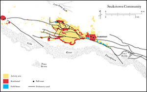
Snaketown is famous for its Mesoamerican-style ball court, but the canals that watered fields as much as two miles away from the Gila river are even more impressive.
(Reprinted by permission from The Hohokam Millenium, copyright 2007 by the School for Advanced Research Press, Santa Fe, New Mexico)
Between 1150 and 1450, after almost a millennium of relative stability, profound changes occurred in Hohokam society. These three centuries were a time of unstable environmental conditions. The instability coincided in part with the major droughts of the Medieval Warm Period that descended on the Southwest and contributed to the abandonment of Chaco Canyon and its great houses and, later, large pueblos at Mesa Verde and in the nearby Moctezuma Valley. In the desert, this same period may have been a time of floods that altered river channels and undermined canal systems, as well as sometimes prolonged droughts that caused water shortages. We know little of these environmental perturbations, but we do know that Snaketown on the Gila River lost population. Meanwhile, other communities such as Casa Grande consolidated formerly separate canal systems into a single irrigation network based on a 21-mile canal that watered 15,000 acres. Five villages, each with their own platform mounds, lay along the canal. Another irrigation community in present-day Mesa had 21 miles of canals that watered 14,000 acres of fields. By any standards, this was irrigation on a large scale, with the largest Phoenix Basin communities each supporting between six and 10 thousand people.
As the social order changed, so environmental pressures appear to have intensified. Just how, we don't know, but the massive irrigation systems no longer produced the food surpluses necessary to support the now much more elaborate Hohokam society. The collapse came around 1450, probably a rapid dispersal, household by household, as people moved away to settle with kin or farmed on a much smaller scale. Their successors were the Akimel O'odham, probably their direct descendants, who built more modest irrigation works atop those of earlier times.
In 1882, 400 years after the Hohokam dispersed, Smithsonian anthropologist Frank Hamilton Cushing came to the Salt River Valley. He climbed to the top of an earthen monument and was astonished to find himself in the heart of a long-abandoned Indian settlement. He wrote: "It was one of the most extensive ancient settlements we had yet seen. Before us, to the north, east, and south, a long series of...house mounds lay stretched out in seemingly endless succession."
Cushing was by no means the first outsider to explore the valley. In 1865, the United States Cavalry had established Camp McDowell in what is now Maricopa County. Enterprising visitors observed not only the eroded mounds of what were once adobe structures, but also the remains of extensive irrigation canals that had once brought water from the Salt River to wide tracts of now-abandoned maize fields. In 1867, Jack Swilling, a former soldier, established the Swilling Irrigating and Canal Company. The company flourished, for its canals often followed those of the ancient farmers, and the farms prospered despite the extremely hot summers. On October 20, 1871, a mass meeting of settlers appointed a committee to select a town site. After considerable debate, committee member Darrell Duppa proposed the name Phoenix, for a city rising Phoenix-like on the ruins of an ancient civilization.
Farther north, Mormon settlers arrived at the Great Salt Lake. Brigham Young himself declared that this was their new homeland. Within days, the brethren had a small dam and ditches irrigating a five-acre field of potatoes. Their tools were simple, their dams scraped together from earth and stones, but their willpower was inexhaustible. The pioneers lived in a close-knit society in which the church decided where to capture water and how to distribute it. Mirroring the Hohokam system, the water from the nearby Wasatch Mountains belonged not to individuals but to everyone, resulting in small communities that were sustainable over many generations. By 1910, small-scale farmers in Utah irrigated nearly 1 million acres.
Small groups of farmers living in sustainable communities: The idea appealed strongly to John Wesley Powell of Colorado River fame, who spent time among the Mormons and acquired a profound knowledge of the desert West at a time when few Easterners had been there. On the face of it, the obvious thing to do was to leave most of the West unpopulated except for isolated, better-watered enclaves. However, such thinking ran contrary to doctrines of progress, western expansion, and proper use of the land for agriculture. Besides, America would become two lands separated by desert. Only one weapon would suffice to master the arid lands—water. The dream was a glorious vision of fertility and prosperous farms, and a wonderful concept for ambitious politicians looking to deliver jobs in the form of water engineering projects to their constituents.
Today, the southwestern U.S. faces a variety of pressures on its water supply. Temperatures are rising, while rainfall and river flows are dropping. The area is in the middle of a drought that is as severe as any that has struck in the past 100 years. At the same time, the Southwest is experiencing rapid population growth. The U.S. Census Bureau projects that by the year 2030 the population of Arizona will grow by five million people. Glen MacDonald, a geography professor at the University of California, Los Angeles, writing in the December 14, 2010, edition of the Proceedings of the National Academy of Sciences, makes the point that engineering projects designed to transfer and store water cannot completely supply the increased need for water. Industrial and agricultural water use must become more efficient, and residential water use must decrease dramatically by limiting the amount of water used for swimming pools and landscaping.
Humans have managed water successfully for thousands of years in ways that are often ignored by history. But their experiences tell us that it is the simple and ingenious approaches that often work best—local water schemes, decisions about sharing and management made by kin, family, and small communities. These experiences teach us that self-sustainability is attainable.
Brian Fagan is a contributing editor to ARCHAEOLOGY.
Copyright ©2011 Brian Fagan.
From: Elixir: A History of Water and Humankind by Brian Fagan. Reprinted by permission of Bloomsbury Press.