From the war diary of USS Aylwin
Sunday, 1 September, 1918
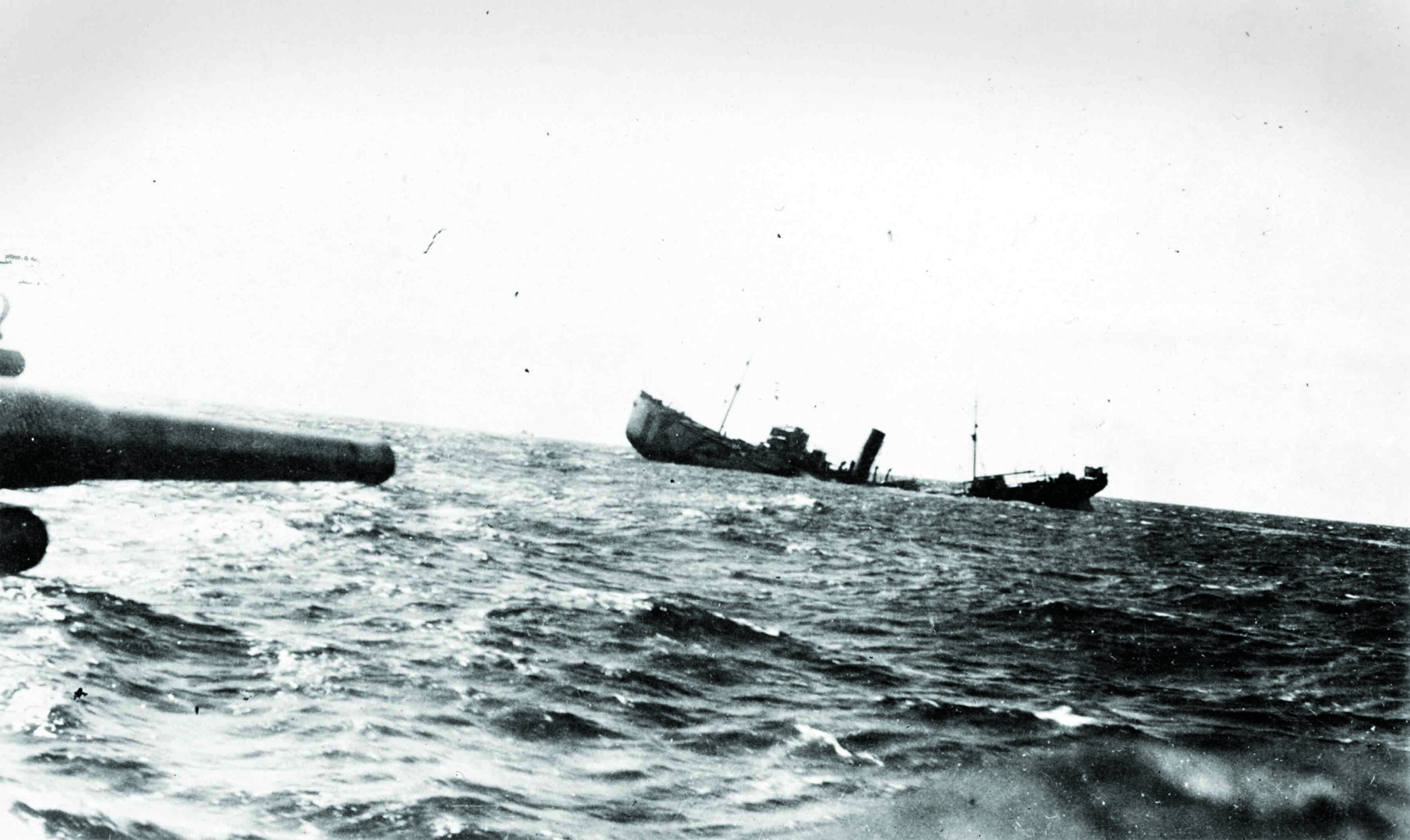
Proceeding as part of escort of combined convoys O.E.21 and O.L.32 through the Irish Sea. About 1 P.M. near entrance to St. George’s Channel two ships of the convoy, the Mesaba and City of Glasgow, were torpedoed. No trace of submarine nor of the torpedo was seen. Dropped 30 depth charges on probable position of spot and proceeded with convoy. About 6 P.M. at the southern entrance of St. George’s Channel a ship in the convoy, the ACTOR was torpedoed. Dropped a barrage of 48 depth charges on what appeared to be the origin of the wake of the torpedo and near spot where periscope was reported to have been seen. The ACTOR was not badly damaged and was eventually towed into port by tugs sent out from Queenstown. Proceeded with convoy.
By the summer of 1917, during World War I, circumstances in Britain were extremely dire. Since 1914, the lives of 40,860 British merchant seamen, fishermen, and passengers had been lost, and 5,696 ships sunk, most by the dozens of German U-boats patrolling the Atlantic. The threat was grave not just to those crossing the seas, but to Britain itself, which, by many estimates, had only about six weeks of food remaining. “Britain was only ever going to succumb to Germany if the country starved, and the Germans came very close to succeeding,” says archaeologist Innes McCartney of Bangor University. “The merchant marine was being decimated and Britain wasn’t able to produce new ships as quickly as they were going down.” What changed the tide of the war and saved Britain from both starvation and defeat was the introduction of the convoy system, in which ships would travel together in groups. “The convoy system was brought in as a last desperate measure to stop the Germans from sinking merchant ships that were sitting ducks when sailing alone,” says McCartney. Thus, when U-boat crews spotted smoke on the horizon, it was no longer from a lone ship, but from a group of ships protected by the navy. “That changed the game completely,” he says.
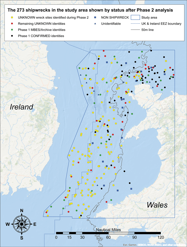
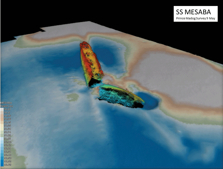
Now, an expansive archaeological survey has revealed new information about hundreds of ships whose stories had been incorrectly or incompletely told. The physical impact of these vessels on the seafloor holds lessons not just for archaeologists and military historians, but for scientists searching for ways to erect the structures needed to produce renewable energy. From 2012 to 2021, marine geoscientist Michael Roberts and a team from Bangor University scanned 7,500 square miles of the Irish Sea floor using multibeam sonar. The team mapped 273 wrecks, including those of trawlers, cargo vessels, submarines, ocean liners, and tankers—some of which, says McCartney, have rare designs or are of national importance, while others are naval graves.
McCartney compared the shipwrecks Roberts’ team had located with the U.K. Hydrographic Office’s database of wrecks. He found that the portion of unidentified or misidentified ships in this area, which was originally thought to be 37 percent, was actually 59 percent. “The first phase of the research was to validate everything that was known about the wrecks, and the second phase was to try to identify the mystery ones,” says McCartney. “The conclusion to be drawn is that we know far less about the names of U.K. shipwrecks than was previously believed. One of the things we can do using this huge data set is correct that.” Eighty percent of the previously unidentified ships in the survey now have their correct names. And, McCartney says, there’s no reason why this same technique couldn’t be brought to bear on all the 9,845 shipwrecks in the seas around the United Kingdom—about 4,000 of which are unidentified—in exactly the same way.
The majority of the 273 ships mapped by Roberts’ team were sunk during the two world wars. For McCartney, the World War I–era ships provide important examples of how to use the survey data. “World War I at sea is primarily a war against U-boats and is the longest battle of the war,” he says. “This study combines landscape archaeology and battlefield archaeology and involves thousands upon thousands of objects.” The survey has allowed McCartney to archaeologically document the success of the convoy system. “Nearly all of the World War I shipwrecks we see were sunk while sailing independently,” he says. “Convoy losses are comparatively rare.”
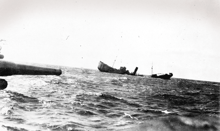
There are, however, two ships identified by the survey that were sunk despite being part of convoys. The merchant steamships SS Mesaba and SS City of Glasgow are both large vessels known to have been sunk on September 1, 1918, by submarine UB 118, killing all on board. Six years before, Mesaba had had a small role in one of history’s most famous shipwrecks. While crossing the Atlantic, the crew of Mesaba radioed a message to RMS Titanic warning her to beware of icebergs. The message never reached Titanic’s bridge.
The survey has also presented the opportunity to correct the historical record with respect to the WWII-era anti-submarine minefields around Britain. “Before my U-boat studies began in 1997, only three U-boats were thought to have been sunk by mines around the U.K. in World War II, but now there are nine,” McCartney says. “Unidentified submarine wrecks are just as important to identify as any other mystery shipwreck. Archaeological survey of these wrecks is, over time, changing the narrative of aspects of the world wars.” And it’s not only archaeologists for whom the data from the survey is critical. Some of the wrecks pose an environmental threat. One of four tankers McCartney identified is known to have been carrying heavy fuel oil, which is used for marine engines. It is much denser than regular oil and contains particularly harmful contaminants, making a spill or leak highly destructive. Other vessels contain unexploded munitions. “It’s important to know where these things are so they can be managed,” McCartney says.
The ships are also providing a huge amount of information to companies searching for stretches of seabed stable enough to support the structures needed to create wind farms. “Ships offer a proxy for how metal structures on the seabed for decades weather and change over time,” says Roberts. “The clock is ticking, because in fifty years those ships might not be there.” According to McCartney, accurate dating of such a large number of wrecks in one area will have a major impact on the study of seabed dynamics, creating better models for the placement of wind farms and tidal generators. And, for archaeologists seeking relatively low-cost, noninvasive ways to explore the landscapes of the past, surveys such as this are invaluable. “Multibeam underwater geophysics is doing for the undersea landscape what aerial photography did for the terrestrial landscape in the 1920s,” says McCartney. “We can see the undersea landscape in a completely different way, and we are at the forefront of a really interesting time.”