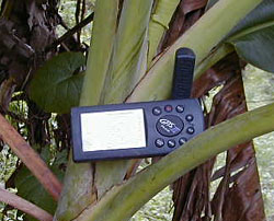
The Garmin III GPS receiver at work near the entrance of Hummingbird Cave collecting positional data from orbiting satellites |
Our work in the Roaring Creek Valley broadened the geographical range of the sampling of the Remote Sensing Project. While stationed at the WBRCP jungle camp known as the "Xibalba Hilton," we recorded data at six different cave entrances in this region.
Cave: Actun Tunichil Muknal
Crew: Cameron Griffith, Rusty Peterson, Meghann Lundy
The first cave we visited in the valley was one of the more important caves in the WBRCP research design. Actun Tunichil Muknal is a very impressive cave, not only in terms of the beautiful rock formations, but also because of the archaeological assemblage that was excavated by the WBRCP in 1997 and 1998. This cave is located just 50 meters from the camp. Tunichil Muknal has a large vertical entrance that is located at the base of a karst rock face. It is the source for the Muknal stream, whose cold waters flow outside the cave for about 130 meters before meeting up with the significantly warmer Roaring Creek. We believe that such a temperature difference will likely show up in the thermal band of certain satellite images. In a situation such as this, it is also likely that the species growing in and around the stream will be apparent in the visible bands of the satellite image(s). If these environmental conditions show up on the images, we can use the information from Tunichil Muknal to locate similar streams in Belize. Where the streams disappear into landforms may be where cave entrances are located.
Cave: Actun Uayazba Kab
Crew: Cameron Griffith, Rusty Peterson, Meghann Lundy, Leon Benrimon
Actun Uayazba Kab is a rough translation for "Handprint Cave." It is named so because several negative handprints were found on the cave. Uayazba Kab is dry and is located halfway up a karst rock face. It has two large entrances that are similar in height and width to the entrances of Actun Halal. Uayazba is a dry cave, but it becomes active in times of extremely heavy rainfall in the area. This, coupled with the modest dark zone component, results in ambient temperatures near the entrance of the cave that are significantly cooler than the surrounding jungle. This may be detectable in the thermal bands of certain satellites.
Cave: Actun Nak Beh
Crew: Cameron Griffith, Rusty Peterson, Sherry Gibbs
Actun Nak Beh translates to "Cave at the End of the Road." It is named so because there is a sacbe, which means "white road," that leads from the cave entrance to the surface site Cahal Uitz Na. Actun Nak Beh has a horizontal entrance like a rock-shelter. It is at the base of a limestone karst hill and will flood periodically. During the month of July, Nak Beh flooded badly enough to fill one of the excavation units in the entrance. This periodic flooding, along with the pinpointed dates of the hydrologic activity, may help us locate caves with similar hydrologic properties.
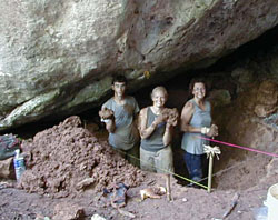
Rusty Peterson, Becca Lafferty, and Michaela Reisinger clear mud from Unit 1 following the flooding in the entrance of Actun Nak Beh. |
Cave: Actun Yaxteel Ahau
Crew: Cameron Griffith, Rusty Peterson
Yaxteel Ahau translates to "Cave of the Ceiba Tree Lord." Yaxteel has a large horizontal entrance and a number of sinkhole entrances. The Yaxteel stream flows from this entrance and its cold waters flow for about 300 meters before it, like the Muknal stream, meets with the much warmer waters of the Roaring Creek. With regard to the remote-sensing signatures, Actun Yaxteel Ahau and Actun Tunichil Muknal are very similar. It will be interesting to see if a pattern for caves with streams emerges from caves such as these.
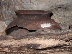
An olla neck becoming encased in calcite in Actun Yaxteel Ahau |
Cave: Laberinto de las Tarantulas
Crew: Cameron Griffith, Rusty Peterson
Laberinto de las Tarantulas translates to "Labyrinth of the Tarantulas." Tarantula Cave is located near the base of a karst limestone hill. It has two small horizontal entrances that blow cool air. Because of the diminutive size of these entrances the external temperature differential is not as great as that from the caves with larger entrances. This cave does have animal activity i.e. bats, gibnuts, snakes, insects, and spiders (especially tarantulas). One of the most interesting aspects of Tarantula Cave is a large slate stelae monument within a small chamber. This monument is quite similar in size to those found in the stelae chamber of Actun Tunichil Muknal.
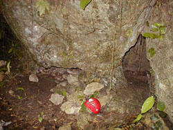
Entrance One of Laberinto de las Tarantulas |
Cave: Hummingbird Cave
Crew: Cameron Griffith, Rusty Peterson
Hummingbird Cave has not yet been explored by the WBRCP. As we did not have the minimum number of people to safely explore the cave (three people), we did not conduct reconnaissance within the cave. However, we were able to collect data for the remote-sensing project outside the entrance. Hummingbird Cave is at the base of a hill, and like Yaxteel and Tunichil it has a stream flowing out of it that eventually merges with the Roaring Creek. Hummingbird Cave should strengthen the data base for a cave signature, either thermal- or vegetation-specific, for caves with constant water flow.
Remote Sensing Intro | September 18