Features
The City at the Beginning of the World
By LIZZIE WADE
Friday, June 08, 2018
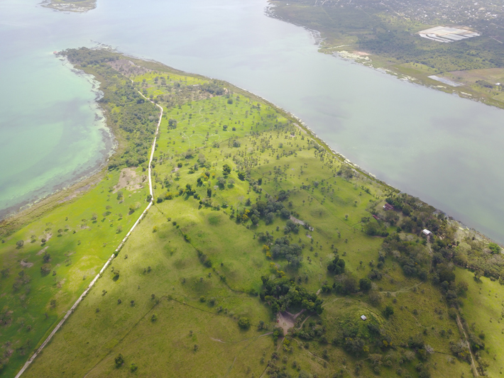
For years, archaeologist Timothy Pugh thought he was simply following the cows as he walked across the site of Nixtun-Ch’ich’, an ancient Maya city in northern Guatemala. The site, whose name means, roughly, “a rocky place,” is located on a peninsula that juts out like a pointed finger into Lake Petén Itzá. It is now part of a cattle ranch, covered with tall grass—perfect grazing land. Most of the other Maya sites in the area are obscured by dense thickets of jungle, so this was a lucky break for Pugh and his colleagues. Still, the nearly knee-high vegetation wasn’t easy to move through. Pugh tended to follow the paths the cattle had already created as they tamped the grasses down with their hooves while they grazed, picking their way between mounds containing the remains of ancient ceremonial platforms up to 13 feet high.
With an area of about one square mile, Nixtun-Ch’ich’ was unusually compact compared to other Maya cities, which were largely spread out throughout the jungle. Back in 1995, Pugh, now at Queens College, and his adviser at the time, Prudence Rice, an archaeologist and professor emerita at Southern Illinois University Carbondale, mapped the site by identifying ancient buildings from their raised outlines on the surface and recording a GPS point at each of their corners. But by 2013, Pugh thought the map of Nixtun-Ch’ich’ was due for an update. New technology had transformed mapping techniques, allowing archaeologists to gather more GPS data than ever before, including subtle changes in terrain. “We collected 80,000 points in just a few months. With the old machines, that would have taken years,” Pugh says. More importantly, he no longer had to limit himself to the buildings he could see. Now, Pugh could simply record a GPS point every 6.5 feet, whether he thought there was a building there or not. “In that way, you don’t bias the data while you’re working,” he says.
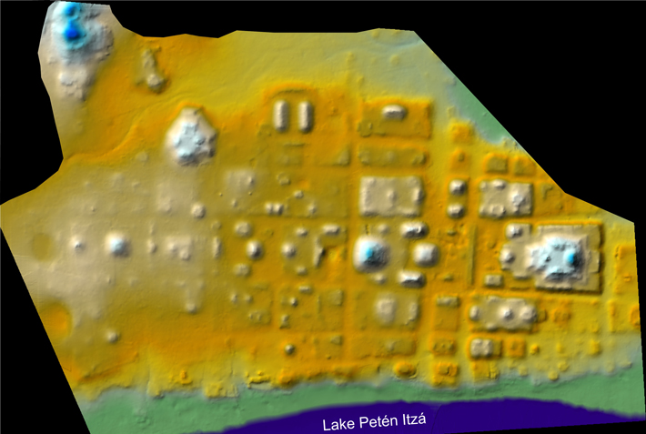 The effort quickly paid off. The GPS equipment detected slight rises and falls in the landscape that had been all but invisible beneath the grass. Buildings and streets Pugh hadn’t noticed before began emerging from the data. And when he started piecing together a new, more complete picture of Nixtun-Ch’ich’, a striking pattern jumped out at him. The city’s buildings were arranged in straight lines, like the structures on a modern city block. Major streets ran almost exactly east-west, with shorter north-south avenues intersecting them at nearly perfect 90-degree angles. It was unmistakable: Nixtun-Ch’ich’ was laid out on a grid, an urban form so unusual in Mesoamerica that Pugh and Rice had never even thought to look for it. Pugh then realized that the paths he had been following through the grass weren’t originally created by grazing cattle. The animals were walking along ancient streets, and he had been too.
“In the Maya area, it’s unique,” says Pugh. “There’s no other site like it that we know of yet.” David Freidel, an archaeologist at Washington University in St. Louis who studies the Maya, agrees. “It’s an astonishing discovery,” says Freidel. “It’s a planned, gridded city. It has big plazas, big pyramids...it has everything you expect, only it’s not dispersed over a landscape.” Nixtun-Ch’ich’ is so far outside the norms of Maya city planning that Pugh and Rice first thought that foreigners must have built it. But as they’ve continued to excavate, they’ve realized that Nixtun-Ch’ich’ was unequivocally a Maya invention—and that it might reveal why these ancient people settled down and built cities in the first place.
Westminster Abbey’s Hidden History
By JASON URBANUS
Friday, June 08, 2018
Westminster Abbey is one of the most famous buildings in Christendom. It has stood witness to signal events, serving as the site of English coronations for almost one thousand years, hosting dozens of royal weddings and funerals, and containing the tombs of monarchs, poets, scientists, and countless other notable Britons. Recently, it was the site of an unusual archaeological dig. The excavations did not take place outside on the Abbey’s grounds, as might be expected, but instead in the triforium—an arcaded gallery some 70 feet above the nave, or central aisle.
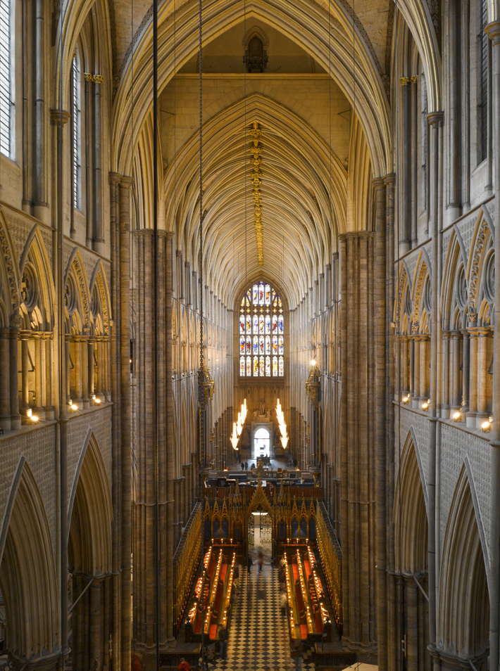 The 20th-century poet John Betjeman described the triforium as offering the “best view” in Europe. Today, many people have, without realizing it, experienced that vantage point on television. The cameras that broadcast important Abbey ceremonies are often stationed in the triforium to provide a bird’s-eye view of the events. The gallery itself has not been open to the public since it was built in the thirteenth century, but that is set to change. Abbey authorities have decided to transform it into a museum space, soon to be known as the Queen’s Diamond Jubilee Galleries. Since the triforium is currently only accessible via a narrow wooden spiral staircase, a new tower, which will provide visitors with direct access to the triforium from outside, is being constructed. This is the first major architectural addition to the Abbey in 350 years.
Advertisement
Also in this Issue:
Advertisement
IN THIS ISSUE
Features
Westminster Abbey’s Hidden History
The City at the Beginning of the World
Letter from England
From the Trenches
Sun Storm
Off the Grid
Honoring Osiris
Mirror, Mirror
Pompeii Revisited
Nazi Sub Discovered
Divine Invitation
Samurai Nest Egg
Far From Home
Late Antique TLC
Pinpoint Precision
A Final Account
Seaworthy Sumerians
Tales Out of School
World Roundup
New Mexico’s giant sloth, Peruvian llama sacrifice, Sweden’s oldest onion, bovine brain surgery, and the first Arabians
Artifact
It was a bout time, too
Advertisement

Recent Issues
-
 May/June 2024
-
 March/April 2024
-
 January/February 2024
-
 November/December 2023
-
 September/October 2023
-
 July/August 2023
-
 May/June 2023
-
 March/April 2023
-
 January/February 2023
-
 November/December 2022
-
 September/October 2022
-
 July/August 2022
-
 May/June 2022
-
 March/April 2022
-
 January/February 2022
-
 November/December 2021
-
 September/October 2021
-
 July/August 2021
-
 May/June 2021
-
 March/April 2021
-
 January/February 2021
-
 November/December 2020
-
 September/October 2020
-
 July/August 2020
-
 May/June 2020
-
 March/April 2020
-
 January/February 2020
-
 November/December 2019
-
 September/October 2019
-
 July/August 2019
-
 May/June 2019
-
 March/April 2019
-
 January/February 2019
-
 November/December 2018
-
 September/October 2018
-
 July/August 2018
-
 May/June 2018
-
 March/April 2018
-
 January/February 2018
-
 November/December 2017
-
 September/October 2017
-
 July/August 2017
-
 May/June 2017
-
 March/April 2017
-
 January/February 2017
-
 November/December 2016
-
 September/October 2016
-
 July/August 2016
-
 May/June 2016
-
 March/April 2016
-
 January/February 2016
-
 November/December 2015
-
 September/October 2015
-
 July/August 2015
-
 May/June 2015
-
 March/April 2015
-
 January/February 2015
-
 November/December 2014
-
 September/October 2014
-
 July/August 2014
-
 May/June 2014
-
 March/April 2014
-
 January/February 2014
-
 November/December 2013
-
 September/October 2013
-
 July/August 2013
-
 May/June 2013
-
 March/April 2013
-
 January/February 2013
-
 November/December 2012
-
 September/October 2012
-
 July/August 2012
-
 May/June 2012
-
 March/April 2012
-
 January/February 2012
-
 November/December 2011
-
 September/October 2011
-
 July/August 2011
-
 May/June 2011
-
 March/April 2011
-
 January/February 2011
Advertisement


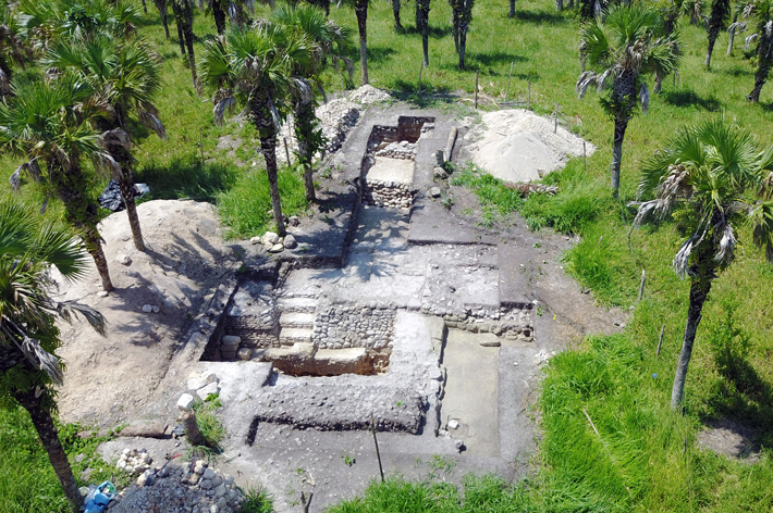
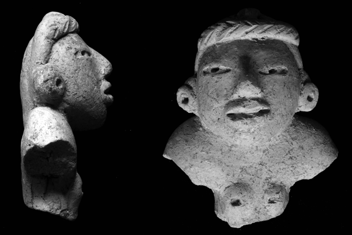 When Pugh and Rice excavated in Nixtun-Ch’ich’, however, they realized the grid was much older than they had initially thought. As they dug into the streets and avenues, they uncovered ancient plaster surfaces that once functioned like pavement, and they were able to collect tiny pieces of bone and charcoal. Once these had been radiocarbon dated, it became evident that the grid had been built before 500 B.C., at least 900 years before the Teotihuacanos arrived in the Maya area.
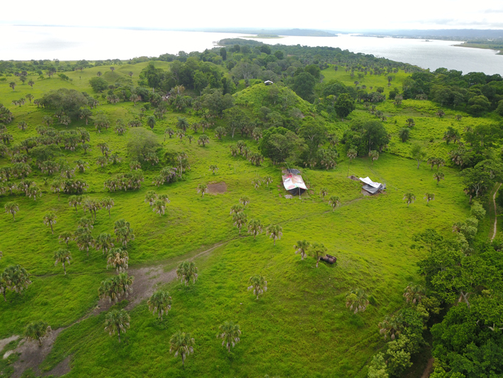
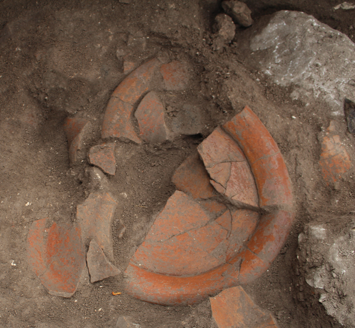 Pugh and Rice found evidence that the people of Nixtun-Ch’ich’ likely gathered at the cenote for rituals. Their excavations uncovered terraced walls along the edge of the cenote, where large groups of people could sit or stand during ceremonies. The ceramics they found in the depression were mostly large serving vessels, and they also uncovered turtle and other animal bones and snail shells—likely the remains of community-wide feasts.
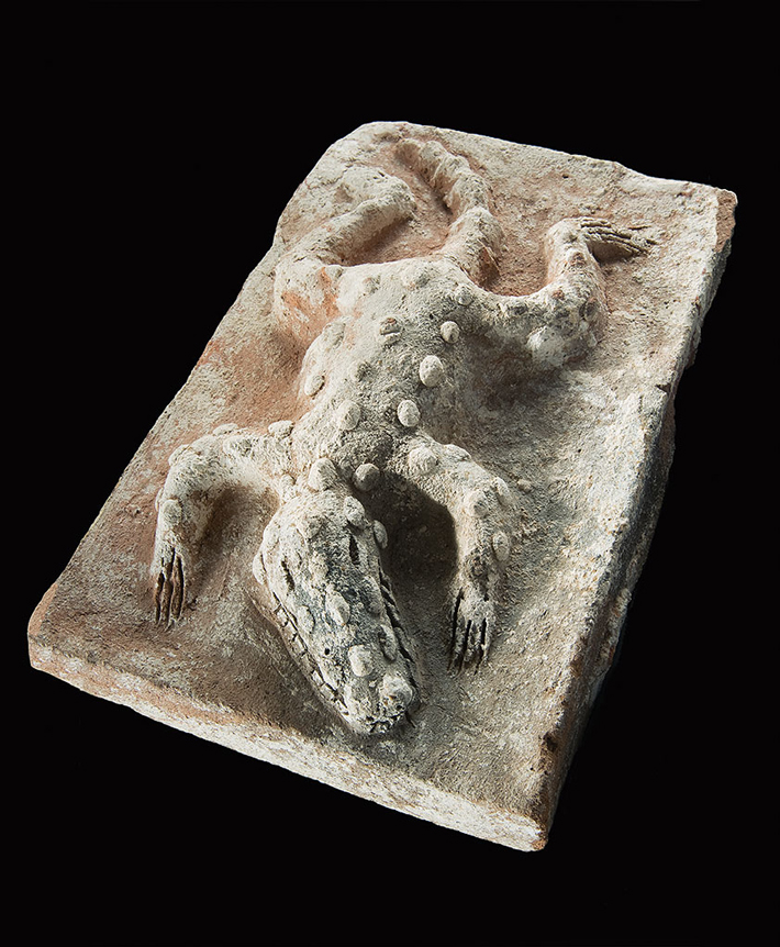 “I see the similarities—it’s pretty hard not to,” says Kathryn Reese-Taylor, an archaeologist at the University of Calgary who studies early Maya cities. “If it’s anything, it would be a crocodile. But that’s a very difficult hypothesis to actually prove.” Inomata agrees. Without a one-of-a-kind artifact like a painting or a diorama that explicitly compares the layout of Nixtun-Ch’ich’ to a crocodile, he says it’s impossible to know if that’s what the builders of Nixtun-Ch’ich’ had in mind.
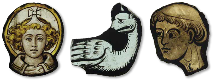 In the lead-up to these changes, church officials have faced the daunting task of both renovating the space and removing material that had collected there for 700 years. “The triforium gallery has never had a meaningful use and it served as an attic,” says archaeologist and Westminster Abbey consultant Warwick Rodwell. But what an attic it is! Over the centuries, it has gradually become filled with broken, precious objets d’art, architectural adornments, and even long-forgotten and displaced stone monuments. “It was the place where you stored all the things you didn’t know what to do with, including old furniture, books and papers, unwanted stained glass windows, and all sorts of odds and ends,” he says.
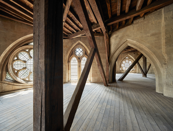
 During the current campaign of renovations, when the floorboards were lifted, Rodwell encountered centuries-old historical debris. Since then, he has overseen the archaeological excavation of the triforium. “When I first crawled around the vaults, under the timber floors, I realized that there was considerable archaeological potential in the ‘rubbish.’” he says. “Consequently, I planned the operation of cleaning out the vault pockets in an orderly archaeological fashion. This is the first time a professional archaeological investigation of the contents of vault pockets has been carried out in the UK.” Overall, more than 4,000 trash bags containing material spanning seven centuries were filled, removed, and their contents sorted.
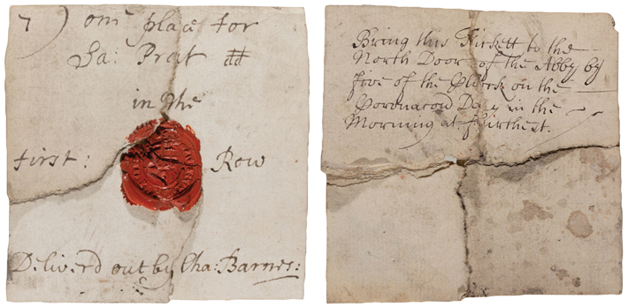
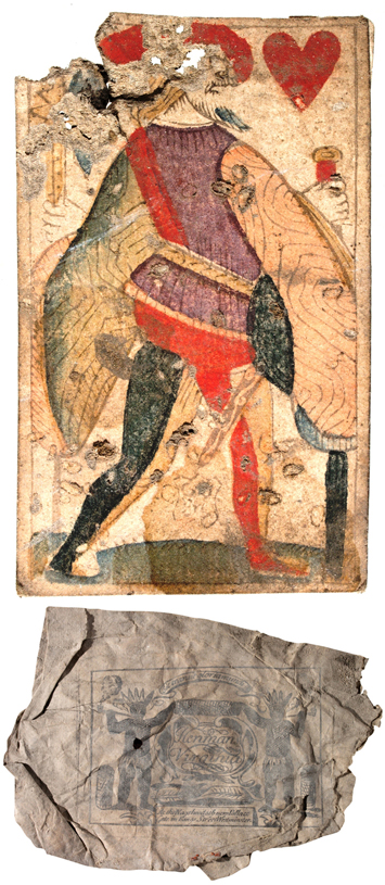 A brand-new perspective on the use of the triforium over time, and of the people who occasionally visited this difficult-to-access level, is now the result. Among the objects discovered are animal bones—leftover from meals—sherds of pottery, fragments of glass vessels, tobacco wrappers, newspapers, pages from books, a leather knife scabbard, and even shoes. A rare seventeenth-century playing card and four handwritten invitations to the coronation of Queen Anne, likely left behind by spectators who witnessed the 1702 ceremony, were also salvaged.
 Jason Urbanus is a contributing editor at ARCHAEOLOGY.
