


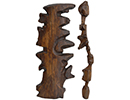
Marshall Islands Stick Chart

May/June 2019
 The education of a navigator in the Marshall Islands, a Micronesian archipelago in the South Pacific, traditionally began by being blindfolded in a canoe. Young sailors learned to feel and intuit the motion of the sea before ever venturing out on ocean journeys. The deep Marshallese connection with waves and their movements reaches back more than 2,000 years to land-finding techniques used by the islands’ first settlers.
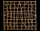
Scholars have identified two different types of Marshall Islands stick charts, wooden diagrams the Marshallese have been producing since at least the middle of the nineteenth century. The first and probably older type, shown here, contains abstract representations of how waves interact with bodies of land in general. The second type illustrates actual islands, often represented by cowrie shells, along with swell patterns identified and recorded by pilots. “There aren’t that many examples from across the Pacific of this kind of navigational knowledge being encoded or physically represented,” says anthropologist Joseph Genz of the University of Hawaii. He says the charts were used mainly as teaching devices rather than real-time way-finders. They help to impart perhaps the most crucial concept in the Marshallese navigational tradition, that of the dilep, or “backbone wave.” “People still describe the dilep as the most important wave to find,” Genz says. “It’s like a path you can follow to the next atoll. Instead of going landmark to landmark, you go seamark to seamark.”

Advertisement
IN THIS ISSUE
Features
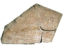
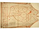
Mapping the Past
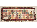
Bringing Back Moche Badminton
Inside King Tut’s Tomb
Letter from the Dead Sea
From the Trenches
Epic Proportions
Off the Grid
Stabbed in the Back
A Fox in the House
Tigress by the Tail
Family Secrets
Cold War Storage
Marrow of Humanity
Maya Beekeepers
Roman Soldier Scribbles
Understanding Hornet's Fate
Viking Warrioress
Colonial Cooling
Temple of the Flayed Lord
Celtic Curiosity
Submerged Scottish Forest
World Roundup
American whaler petroglyphs, Chinese “elixir of immortality,” Neanderthal footprints, and Ice Age rabbit hunting
Artifact
At some point in the past
Advertisement

Recent Issues
-
May/June 2024
-
 March/April 2024
-
 January/February 2024
-
 November/December 2023
-
 September/October 2023
-
 July/August 2023
-
 May/June 2023
-
 March/April 2023
-
 January/February 2023
-
 November/December 2022
-
 September/October 2022
-
 July/August 2022
-
 May/June 2022
-
 March/April 2022
-
 January/February 2022
-
 November/December 2021
-
 September/October 2021
-
 July/August 2021
-
 May/June 2021
-
 March/April 2021
-
 January/February 2021
-
 November/December 2020
-
 September/October 2020
-
 July/August 2020
-
 May/June 2020
-
 March/April 2020
-
 January/February 2020
-
 November/December 2019
-
 September/October 2019
-
 July/August 2019
-
 May/June 2019
-
 March/April 2019
-
 January/February 2019
-
 November/December 2018
-
 September/October 2018
-
 July/August 2018
-
 May/June 2018
-
 March/April 2018
-
 January/February 2018
-
 November/December 2017
-
 September/October 2017
-
 July/August 2017
-
 May/June 2017
-
 March/April 2017
-
 January/February 2017
-
 November/December 2016
-
 September/October 2016
-
 July/August 2016
-
 May/June 2016
-
 March/April 2016
-
 January/February 2016
-
 November/December 2015
-
 September/October 2015
-
 July/August 2015
-
 May/June 2015
-
 March/April 2015
-
 January/February 2015
-
 November/December 2014
-
 September/October 2014
-
 July/August 2014
-
 May/June 2014
-
 March/April 2014
-
 January/February 2014
-
 November/December 2013
-
 September/October 2013
-
 July/August 2013
-
 May/June 2013
-
 March/April 2013
-
 January/February 2013
-
 November/December 2012
-
 September/October 2012
-
 July/August 2012
-
 May/June 2012
-
 March/April 2012
-
 January/February 2012
-
 November/December 2011
-
 September/October 2011
-
 July/August 2011
-
 May/June 2011
-
 March/April 2011
-
 January/February 2011
Advertisement

