


The Forma Urbis Romae

May/June 2019
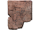
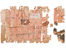
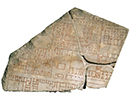
 The Forma Urbis Romae, or map of the city of Rome, was a massive plan of the layout of the city under the emperor Septimius Severus (r. A.D. 193–211). Although only a small portion of the plan survives, scholars are relatively certain it illustrated most of the city. This fragment shows commercial structures on the southeastern slope of the Viminal Hill. The Forma Urbis adorned the wall of a room in Rome’s Temple of Peace that might have served as an archive of maps and records. Drawn at a scale of 1:240, the plan resembles a land surveying map, in that it includes not only streets and blocks, but also interior features of buildings, such as colonnades and staircases. However, its monumental size—60 feet by 43 feet—suggests a decorative rather than practical function, says archaeologist Susann Lusnia of Tulane University. “The Forma Urbis provided an overview of the changes made to Rome by Severus in his quest for legitimacy and establishment of his dynastic succession,” she says. “The marble plan was itself a monument to the Severan legacy in Rome.” Severus’ ambitious building program included both restoration of older monuments and creation of new ones as part of his effort to draw attention to his nascent dynasty.


Advertisement
IN THIS ISSUE
Features
Mapping the Past
Bringing Back Moche Badminton
Inside King Tut’s Tomb
Letter from the Dead Sea
From the Trenches
Epic Proportions
Off the Grid
Stabbed in the Back
A Fox in the House
Tigress by the Tail
Family Secrets
Cold War Storage
Marrow of Humanity
Maya Beekeepers
Roman Soldier Scribbles
Understanding Hornet's Fate
Viking Warrioress
Colonial Cooling
Temple of the Flayed Lord
Celtic Curiosity
Submerged Scottish Forest
World Roundup
American whaler petroglyphs, Chinese “elixir of immortality,” Neanderthal footprints, and Ice Age rabbit hunting
Artifact
At some point in the past
Advertisement

Recent Issues
-
May/June 2024
-
 March/April 2024
-
 January/February 2024
-
 November/December 2023
-
 September/October 2023
-
 July/August 2023
-
 May/June 2023
-
 March/April 2023
-
 January/February 2023
-
 November/December 2022
-
 September/October 2022
-
 July/August 2022
-
 May/June 2022
-
 March/April 2022
-
 January/February 2022
-
 November/December 2021
-
 September/October 2021
-
 July/August 2021
-
 May/June 2021
-
 March/April 2021
-
 January/February 2021
-
 November/December 2020
-
 September/October 2020
-
 July/August 2020
-
 May/June 2020
-
 March/April 2020
-
 January/February 2020
-
 November/December 2019
-
 September/October 2019
-
 July/August 2019
-
 May/June 2019
-
 March/April 2019
-
 January/February 2019
-
 November/December 2018
-
 September/October 2018
-
 July/August 2018
-
 May/June 2018
-
 March/April 2018
-
 January/February 2018
-
 November/December 2017
-
 September/October 2017
-
 July/August 2017
-
 May/June 2017
-
 March/April 2017
-
 January/February 2017
-
 November/December 2016
-
 September/October 2016
-
 July/August 2016
-
 May/June 2016
-
 March/April 2016
-
 January/February 2016
-
 November/December 2015
-
 September/October 2015
-
 July/August 2015
-
 May/June 2015
-
 March/April 2015
-
 January/February 2015
-
 November/December 2014
-
 September/October 2014
-
 July/August 2014
-
 May/June 2014
-
 March/April 2014
-
 January/February 2014
-
 November/December 2013
-
 September/October 2013
-
 July/August 2013
-
 May/June 2013
-
 March/April 2013
-
 January/February 2013
-
 November/December 2012
-
 September/October 2012
-
 July/August 2012
-
 May/June 2012
-
 March/April 2012
-
 January/February 2012
-
 November/December 2011
-
 September/October 2011
-
 July/August 2011
-
 May/June 2011
-
 March/April 2011
-
 January/February 2011
Advertisement

