


Features


Villages in the Sky
By MATT STIRN
Tuesday, May 26, 2020
 The Wind River Range in the Rocky Mountains stretches 100 miles across northwestern Wyoming and the Continental Divide, extending from the thick pine forests of Yellowstone National Park toward the vast grasslands of the Great Plains. From the river valleys and lakes below, the peaks of the mighty “Winds” rise toward the sky, reaching 13,000 feet above sea level. These granite towers pierce the clouds and are surrounded by high-altitude plateaus dotted with tundra and remnants of Ice Age glaciers. From a distance, they appear imposing, barren, and hostile, but closer inspection reveals a vibrant scene—herds of bighorn sheep traversing the horizon, marmots peeking up from boulder fields, and clusters of ancient whitebark pines standing watch over it all.
On the outskirts of a scraggly whitebark pine forest at 11,000 feet above sea level in the northern stretch of the range, a plume of smoke rises from a campfire as lunch is prepared in cast iron cookware over the open flames. Tents are spread out across the alpine meadow, and the whinnies of horses echo against nearby cliffs. It is a scene reminiscent of a nineteenth-century frontier camp, except for the presence of a bright yellow surveying instrument and the metallic ting of trowels as archaeologists scrape them against the pebbly soil. The site, known as High Rise Village, is perched on a hillside that would make a challenging black-diamond ski run. It was a large settlement occupied by the seminomadic Shoshone people from around 4,000 years ago until the nineteenth century. Discovered in 2006 by University of Wyoming archaeologist Richard Adams, High Rise Village was the first and largest of nearly two dozen high-elevation villages to be identified in the Wind River Mountains, and has provided new insight into how prehistoric people thrived in the high alpine zone of the Rocky Mountains.
Alpine archaeology is a relatively new field in North America. Conducting fieldwork in remote high-altitude areas is expensive and physically demanding. “Before the advent of modern, lightweight camping equipment, it often wasn’t possible to run prolonged projects in the mountains,” says Adams. As a result, the craggy peaks and wind-whipped ridges of the American West long remained a blank spot on the map of prehistoric North America.
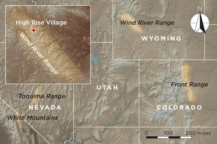 In the 1960s, Colorado State University archaeologist Jim Benedict identified miles of stone walls along the plateaus of Colorado’s Front Range, evidence of communal game drives constructed to corral large herds of bighorn sheep. Around two decades later, University of California, Davis, archaeologist Robert Bettinger discovered multiple alpine villages near 12,000 feet in California’s White Mountains. Farther east, at 11,000 feet in Nevada’s Toquima Range, David Hurst Thomas of the American Museum of Natural History found the Alta Toquima site, remains of a massive prehistoric village high in the alpine tundra consisting of dozens of depressions known as house pits. The discovery of such substantial sites in remote alpine settings was astonishing to many scholars across the western United States who had long considered the mountains too hostile for sustained human occupation. What led ancient people to build at such high elevations was an open question—did they actively choose to live in the alpine tundra, or were they forced there by factors such as population pressure or climate change? This question has fueled debate among alpine archaeologists worldwide, and each summer more researchers venture high into the mountains seeking answers.
 In the fall of 1995, avocational archaeologist and hunting guide Tory Taylor tripped over a bowling ball–size blue rock while taking shelter under some trees during a thunderstorm in the northern Wind River Range. Turning it over, he recognized the object as a bowl that had been carved out of soapstone. Before this, no archaeological work had ever been attempted in the Winds. Several years later, the news of Taylor’s find reached Adams, who was researching soapstone artifacts found throughout the Rocky Mountains. Adams contacted Taylor and, upon learning more about the discovery, planned a survey expedition with him to investigate the area.
 In 2003, when Adams investigated a wickiup, or wooden tepee, that had recently burned in a forest fire, he made what he recalls as one of the most startling discoveries of his career. Where the small wooden structure had once stood amid thick grass and pine trees, the forest fire had revealed a lodge pad, a stone-lined circular platform cut out of the hillslope that had once served as the foundation for a wooden house structure. Thousands of artifacts were eroding out of it. Adams realized that the lodge pad resembled structures found in the alpine villages excavated by Bettinger in the White Mountains and Thomas in the Toquima Range. The discovery showed that prehistoric people hadn’t just occasionally traveled in these mountains, but had actually built at least one semipermanent settlement. “Alpine villages were considered to be an exclusively Great Basin phenomenon,” Adams says. “We were surprised to find that they likely existed in Wyoming, too.” While the find established that alpine villages may have existed in the Winds, Adams needed more evidence to determine if they were common, or if the lodge pad found at the site of the burned wickiup was simply a fascinating anomaly.
 In fall 2006, Adams was exploring a newly burned alpine forest with a team of volunteers. During a lunch break on the side of a steep slope dotted with granite boulders, Joyce Evans, an experienced avocational archaeologist, noticed a platter-size piece of sandstone that stood out against the surrounding rocks. Evans picked up the stone and realized that it was a heavily used grinding stone, or metate. It was clear evidence that prehistoric people had not only settled on this slope, but also had invested long periods of time there, as it would have taken several generations of grinding to make a rough sandstone so smooth and polished. Walking a few hundred feet from the rest of the team, Evans found a flat platform cut into the hillside that was full of chert flakes, and then another with a projectile point, and still more encircled by stone walls. Unbeknownst to them, Adams and his team had sat down for a rest in what turned out to be the largest alpine village yet discovered in the Rocky Mountains.
 Despite the recent forest fire, the buried archaeological remains at High Rise Village, including the remains of tepee- and log cabin–shaped wooden wickiups that once stood atop the lodge pads, were exceptionally well-preserved. Many of the lodges also contained well-preserved hearths. Radiocarbon dating of charcoal from the hearths showed that people lived at High Rise Village as early as 2000 b.c., and that it was occupied continuously until about a.d. 1850. The artifacts the team recovered from the nine-foot-wide circular pads numbered in the tens of thousands, and included hundreds of chert and obsidian projectile points, as well as knives, scrapers, drills, bone needles, grinding stones, soapstone pendants, red ochre nodules, and broken ceramic vessels. The array of artifacts was typical of those made by the Mountain Shoshone people, also known as Sheepeaters after their affinity for hunting sheep. It’s likely that a band of that tribe inhabited the village.
 When not excavating at High Rise Village, Adams and his team ventured farther into the Wind River Range. They recorded nearly 100 prehistoric sites, identified quarries where soapstone was mined, and found four more, smaller, alpine villages. After years of working at High Rise Village, Adams became adept at spotting the faint remains of lodge pads. “I realized that the majority of lodge pads were informal and relatively difficult to recognize,” Adams says. “There was a good chance that before High Rise, we had walked right through several villages.” Adams returned to several previously identified sites, including the burned wickiup, and discovered that many were part of large prehistoric villages that had been overlooked. In addition to finding that alpine villages were much more prevalent than previously known, Adams and his team realized that the sites were all located in whitebark pine forests, on inclined sunny slopes, and at 10,500 to 11,000 feet above sea level. It was almost as if ancient people created one alpine village and replicated it atop other mountains throughout the northern Winds.
 Given the prevalence of grinding stones found at the sites and their location in whitebark pine stands, it appeared that the villages’ earliest inhabitants chose their locations in order to harvest and process pine nuts, one of the fattiest food sources available to prehistoric people in Wyoming. To test this hypothesis, the team created a predictive model incorporating satellite, terrain, and environmental information over a large area to identify the best locations for people to harvest the nuts. The team then set out on horseback, toward the higher barren slopes of the Continental Divide, in search of the predicted sites. Using the model as a guide, they traversed turquoise glacial rivers, steered clear of grizzly bears, and navigated miles of alpine boulder fields. Ultimately, they identified 14 more prehistoric villages exactly where the model had predicted they would be.
 But other archaeologists, including Adams, believe the resources available in the mountains drew prehistoric people regardless of conditions in the valleys below, especially during certain seasons. Around mid-July in Wyoming, many low-altitude sources of water dry out, making it challenging for plants and animals to survive. The mountains during this time, however, teem with edible plants and herds of deer, elk, and bighorn sheep. For groups like the Shoshone, who were familiar with the seasonal growing cycles of plants and migration patterns of animals, the mountains would have offered bountiful opportunities for hunting and gathering throughout most of the summer. “I suspect that, as soon as the snow melted, people hiked into the mountains to harvest springtime root crops, then berries and tubers later in the summer, and whitebark pine nuts in the fall,” says Adams. In his view, high elevations provided an environment that was no more difficult to survive in than the surrounding lowlands and required only a familiarity with the landscape.
A Path to Freedom
By JARRETT LOBELL
Friday, May 08, 2020
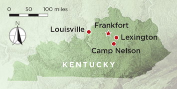
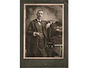
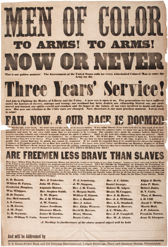
 of Pvt. William Wright, an enslaved man who enlisted at Camp Nelson in Kentucky and was assigned to Company H, 114th U.S. Colored Infantry; an image (above) of a black family fleeing slavery by crossing Union lines taken shortly after the Emancipation Proclamation was issued; a printed broadside (above right) recruiting African Americans for military service was written by Frederick Douglass in Philadelphia.") The only complete original building still standing at Camp Nelson in Jessamine County, Kentucky, is a sizeable house built around 1850 for the just-married Oliver Perry and his bride, the former Fannie Scott, whose family owned the land on which the house sits. It is now called simply the White House. But between 1863 and 1865, at the height of the Civil War, it was just one of more than 300 structures in the center of the camp’s 4,000 acres that housed all the required resources for an army at war. These included a supply depot, hospital, commissary, prison, ordnance storage facility, stables and corrals, a 50,000-gallon reservoir, woodworking shop, blacksmith shop, horseshoeing shop, harness shop, and a bakery that produced 10,000 rations of bread a day. There was also a hotel and tavern called the Owens House, a post office, and a few small eating establishments. Camp Nelson had been built to support the Union Army’s advance into Tennessee, and over its years of wartime service, tens of thousands of soldiers, both white and black, enlisted and were trained there. Camp Nelson was the largest of the eight U.S. Colored Troops (USCT) recruiting centers in Kentucky, and the third largest in the nation. All that remains aboveground, apart from the White House, though, are the remains of eight earthen and two stone forts, the earthen remains of a powder magazine, remnants of a few icehouses, and the stone foundations of two ovens.
The only complete original building still standing at Camp Nelson in Jessamine County, Kentucky, is a sizeable house built around 1850 for the just-married Oliver Perry and his bride, the former Fannie Scott, whose family owned the land on which the house sits. It is now called simply the White House. But between 1863 and 1865, at the height of the Civil War, it was just one of more than 300 structures in the center of the camp’s 4,000 acres that housed all the required resources for an army at war. These included a supply depot, hospital, commissary, prison, ordnance storage facility, stables and corrals, a 50,000-gallon reservoir, woodworking shop, blacksmith shop, horseshoeing shop, harness shop, and a bakery that produced 10,000 rations of bread a day. There was also a hotel and tavern called the Owens House, a post office, and a few small eating establishments. Camp Nelson had been built to support the Union Army’s advance into Tennessee, and over its years of wartime service, tens of thousands of soldiers, both white and black, enlisted and were trained there. Camp Nelson was the largest of the eight U.S. Colored Troops (USCT) recruiting centers in Kentucky, and the third largest in the nation. All that remains aboveground, apart from the White House, though, are the remains of eight earthen and two stone forts, the earthen remains of a powder magazine, remnants of a few icehouses, and the stone foundations of two ovens.
 During recent excavations in an area known from nineteenth-century maps to have been the camp’s only licensed sutler’s establishment, a type of general store, Camp Nelson National Monument archaeologist Stephen McBride and a team from Transylvania University began to uncover picture frames, glass plates, mats, and glass bottles that originally contained chemicals used to develop photographs. They also found bottles embossed with the brand names “Bears Oil,” which had once held hair oil, and “Dr D Jayne,” which had once held hair dye. Soldiers used the dye to darken their hair for portraits, since light hair could appear white in the finished images, prematurely aging the subjects. In addition to these artifacts, the team also uncovered the remains of a small building—the first specialized photography studio ever found at a Civil War site. “The studio wasn’t documented on any extant maps of the camp, and Civil War photos were often taken in tents,” McBride says, “so finding something set up as a permanent photo studio was a real surprise.” The team recovered 10 metal stencils the photographer had used to sign his images and was therefore able to identify him as a man named C.J. Young. (See “The Age of Pictures.”)
But Camp Nelson’s population consisted of more than photographers, merchants, carpenters, blacksmiths, bakers, and soldiers. Many black volunteers arrived with their families, creating a huge influx of refugee women and children. “Camp Nelson is one of the best preserved archaeological sites associated with USCT recruitment,” McBride says. “And it’s also one of the best places to explore the refugee experiences of African American slaves seeking freedom during the Civil War.” Through his work, McBride hopes to resurrect the too-often-lost stories of these women and children uprooted by the war that would determine their destiny.
|
Sidebar:
|
The Age of Pictures
|
 Black military enlistees in Kentucky were in a treacherous position. Kentucky did not secede from the Union, but slavery remained legal, and the state’s political leadership was vehemently opposed to the recruitment or enlistment of African Americans. They reasoned that a person could not be both a soldier and a slave. “The men could enlist with their owner’s permission,” McBride says, “but, as far as I know, not very many slave owners gave their permission.” A rare exception was that of Pvt. William Wright, whose owner, John Russell of Franklin County, allowed him to enlist. Russell received a signing bonus of $300. “Even without permission, black men came anyway, and they were rejected and exposed to violence both coming and going,” adds McBride.
 and a glass bottle of “Dr D Jayne Liquid Hair Dye” (above right) were found in Camp Nelson’s newly discovered photo studio. Both were used by soldiers preparing for their portraits.") On the basis of the animal bones and archaeobotanical evidence that has been unearthed, McBride says that what meat the USCT enlistees did eat consisted of relatively poor cuts of beef, such as ribs and hind shanks, supplemented with pork hams and hocks, and that they consumed a great deal of legumes, particularly beans, cowpeas, and lentils. For refreshment, they had whiskey, beer, and champagne, despite the fact that they were not officially permitted to drink. “Some of the most surprising artifacts we uncovered in the encampment were those associated with women and children, including colored glass beads, a brooch, a barrette, and porcelain doll fragments,” says McBride. “This indicated that wives and children were living with their soldier husbands and fathers, which was strictly against army policy.” The wives and children of soldiers are mentioned rarely, if ever, in records of the time, so these artifacts are some of the only evidence of Camp Nelson’s shadow population.
On the basis of the animal bones and archaeobotanical evidence that has been unearthed, McBride says that what meat the USCT enlistees did eat consisted of relatively poor cuts of beef, such as ribs and hind shanks, supplemented with pork hams and hocks, and that they consumed a great deal of legumes, particularly beans, cowpeas, and lentils. For refreshment, they had whiskey, beer, and champagne, despite the fact that they were not officially permitted to drink. “Some of the most surprising artifacts we uncovered in the encampment were those associated with women and children, including colored glass beads, a brooch, a barrette, and porcelain doll fragments,” says McBride. “This indicated that wives and children were living with their soldier husbands and fathers, which was strictly against army policy.” The wives and children of soldiers are mentioned rarely, if ever, in records of the time, so these artifacts are some of the only evidence of Camp Nelson’s shadow population., fragments (middle) of everyday pottery, and a metal fork (above) found in the pre-expulsion camp were used by refugee women and children.") But families escaping slavery kept coming. “Black men made it clear they were not going to continue to enlist without a path to freedom for themselves and their families,” says Brimmer. In December of 1864, the army began to build the Home for Colored Refugees at Camp Nelson. The status of African Americans was still very much in question as far as Union officials were concerned: Were the women and children legally attached to a soldier? What constituted a legal marriage between enslaved or formerly enslaved people? What about the aging women and men unfit to serve? Nevertheless, more than 3,000 people were allowed into the home during the last year of the war. “While it is true that the camp became more open to women and children,” says Taylor, “and that there were new cottages, an opportunity for schooling and to go to church, and a chance to work and build a new life, the camp was still a significant source of turbulence, danger, violence, illness, and death.”
But families escaping slavery kept coming. “Black men made it clear they were not going to continue to enlist without a path to freedom for themselves and their families,” says Brimmer. In December of 1864, the army began to build the Home for Colored Refugees at Camp Nelson. The status of African Americans was still very much in question as far as Union officials were concerned: Were the women and children legally attached to a soldier? What constituted a legal marriage between enslaved or formerly enslaved people? What about the aging women and men unfit to serve? Nevertheless, more than 3,000 people were allowed into the home during the last year of the war. “While it is true that the camp became more open to women and children,” says Taylor, “and that there were new cottages, an opportunity for schooling and to go to church, and a chance to work and build a new life, the camp was still a significant source of turbulence, danger, violence, illness, and death.”
 While little archaeological evidence of the huts and cabins of the original women and children’s camp remains, McBride has been able to reconstruct what the Home for Colored Refugees looked like through excavation, archival research, and by reviewing photographs. The Home consisted of four dormitories or wards, an office, a two-story school, 97 duplex cottages for nuclear families, and, when the cottages filled up, 60 tents supplied by the army. At the pre-expulsion site of the huts and cabins, McBride found a great deal of evidence of food preparation including ceramics used for serving food, cast-iron kettles, and fragments of steel cooking utensils, as well as evidence of chimneys used for heating and cooking. He also uncovered evidence of food consumption—bones from poor-quality cuts of pork, mediumto poor-quality cuts of beef, chicken bones, and a small number of rabbit and fish bones, as well as liquor bottles. At the Home for Colored Refugees, however, the team found little to no evidence of either food preparation or consumption. Instead, there was a large mess hall where, explains McBride, the army strongly encouraged women and children to eat all their meals rather than cook for themselves.
 against the Persian army commanded by the king Darius III (above right, gesturing toward Alexander).")
Advertisement
DEPARTMENTS
Also in this Issue:
Advertisement
IN THIS ISSUE
Digs & Discoveries
The Parthenon by Any Other Name?
Off the Grid
Guardian Feline
The Cursing Well
If These Walls Could Talk
Warrior Stone
At Press Time
Polychrome Patchwork
Scaredy Cats
Arms and the Women
Birds of a Feather
Viking Knights, Polish Days
Z Marks the Spot
Around the World
Neanderthal clam divers, bananas in Vanuatu, the Maya Great Road, and a secret door in Parliament
Artifact
An emblem of endurance
Advertisement

Recent Issues
-
May/June 2024
-
 March/April 2024
-
 January/February 2024
-
 November/December 2023
-
 September/October 2023
-
 July/August 2023
-
 May/June 2023
-
 March/April 2023
-
 January/February 2023
-
 November/December 2022
-
 September/October 2022
-
 July/August 2022
-
 May/June 2022
-
 March/April 2022
-
 January/February 2022
-
 November/December 2021
-
 September/October 2021
-
 July/August 2021
-
 May/June 2021
-
 March/April 2021
-
 January/February 2021
-
 November/December 2020
-
 September/October 2020
-
 July/August 2020
-
 May/June 2020
-
 March/April 2020
-
 January/February 2020
-
 November/December 2019
-
 September/October 2019
-
 July/August 2019
-
 May/June 2019
-
 March/April 2019
-
 January/February 2019
-
 November/December 2018
-
 September/October 2018
-
 July/August 2018
-
 May/June 2018
-
 March/April 2018
-
 January/February 2018
-
 November/December 2017
-
 September/October 2017
-
 July/August 2017
-
 May/June 2017
-
 March/April 2017
-
 January/February 2017
-
 November/December 2016
-
 September/October 2016
-
 July/August 2016
-
 May/June 2016
-
 March/April 2016
-
 January/February 2016
-
 November/December 2015
-
 September/October 2015
-
 July/August 2015
-
 May/June 2015
-
 March/April 2015
-
 January/February 2015
-
 November/December 2014
-
 September/October 2014
-
 July/August 2014
-
 May/June 2014
-
 March/April 2014
-
 January/February 2014
-
 November/December 2013
-
 September/October 2013
-
 July/August 2013
-
 May/June 2013
-
 March/April 2013
-
 January/February 2013
-
 November/December 2012
-
 September/October 2012
-
 July/August 2012
-
 May/June 2012
-
 March/April 2012
-
 January/February 2012
-
 November/December 2011
-
 September/October 2011
-
 July/August 2011
-
 May/June 2011
-
 March/April 2011
-
 January/February 2011
Advertisement

