Evidence of a lost Mesolithic world lies deep beneath the dark waters of the North Sea
By JASON URBANUS
Thursday, February 10, 2022
On a September night in 1931, the British fishing vessel Colinda was sailing 25 miles off the Norfolk coast of England near the North Sea’s Leman and Ower Banks. Trawlers like Colinda operated by dragging nets across the sea floor, scooping up everything in their path––fish, shells, seaweed, or otherwise. As the crew hauled up their net from a depth of 120 feet, the boat’s skipper, Pilgrim Lockwood, noticed a large block of peat among the catch. As he smacked it with his shovel to break it up and toss it overboard, he hit something hard, which he later recalled sounded like striking metal. Upon examination, Lockwood noticed an unusual object embedded in the clump. It was 8.5 inches long, with a barbed edge, and appeared to resemble some sort of prehistoric harpoon carved from bone or antler. Its discovery would soon alter the field of European prehistory and open the doors to a vast now-submerged landscape hidden beneath the North Sea. After the last Ice Age ended, this became the heartland for generations of European hunter-gatherers before it disappeared under the sea 8,000 years ago. Today, this lost world is known as Doggerland.
Experts from the British Museum who examined the Colinda harpoon, as it came to be called, determined that it likely dated to the Mesolithic period (10,000–4000 B.C.), the era of the hunter-gathers who lived just before the advent of agriculture. Archaeologists wrestled with the question of how such an object had ended up more than 20 miles offshore at the bottom of the North Sea. It seemed unlikely that prehistoric mariners could have dropped it during a fishing expedition, given the limited long-distance seafaring capabilities they possessed at the time.
The scientific world was shocked the year following the artifact’s discovery when pollen analysis carried out on peat extracted from the Leman and Ower Banks indicated that, although it lay 120 feet below the sea, the deposit had formed in a freshwater environment, not a marine one. Whoever had lost the harpoon had done so while walking across land. This revelation was groundbreaking. Although some scholars had theorized that the North Sea was once much lower, as evidenced by the remnants of ancient forests that occasionally protrude out of tidal flats at places such as Pett Level in Sussex, England, the Colinda harpoon was the first tangible piece of evidence suggesting that an extensive landmass had once connected Great Britain to the continent. “It’s an important object because the idea became clear that not only was this a landscape that was not always sea,” says Luc Amkreutz, curator of prehistoric collections at the National Museum of Antiquities in Leiden, “but that it must have been one inhabited by humans.”
Throughout the later twentieth century, further evidence of this drowned world continued to be dredged up by fishing nets, as trawlers raised bone, antler, and stone artifacts that had lain along the seafloor for thousands of years. In the late 1990s this mysterious Mesolithic land finally received a name. The term Doggerland was coined by University of Exeter archaeologist Bryony Coles, who named it after Dogger Bank, a submerged sandbank 60 miles off the English coast frequented by Dutch fishing vessels known as doggers.
This was an area of the North Sea that was proving particularly bountiful in Mesolithic artifacts. However, Doggerland remained frustratingly inaccessible to archaeologists as the deep, murky waters of the North Sea impeded exploration by divers. By the beginning of the twenty-first century, 70 years after the discovery of the Colinda harpoon, there remained just as many questions about Doggerland as answers. The investigation into it had reached a dead end. “People said, ‘We know there is something out there, but we can’t do anything about it, so let’s move on,’” says University of Bradford archaeologist Vince Gaffney. Doggerland remained tantalizingly close, yet still very far away.
Before researchers could determine if and where any archaeological sites might have survived within Doggerland, they had to figure out where its people lived. The North Sea basin covers tens of thousands of square miles, stretching from England to Scandinavia. Since it was nearly impossible to formulate an accurate idea of what Doggerland’s landscape looked like when the last Ice Age ended, it was challenging to know where to even begin looking. According to Gaffney, even with all the technology available today, very little is known about Earth’s oceans and seafloors. “We know more about the surface of the moon,” he says.
To try to solve this nagging problem, Gaffney and a small group of colleagues turned to a resource not commonly used by archaeologists––offshore commercial oil and gas companies. For decades, the petroleum industry had conducted seismic reflection surveys of the North Sea to locate and map mineral deposits. To do this, sound and shock waves are transmitted from a ship and aimed at the seafloor. As they strike different contours, subtleties, and anomalies in the Earth’s crust, the seismic waves are reflected back to the ship at different frequencies and recorded. This data can then be used to produce 2-D and 3-D maps.
Gaffney acknowledges that the team’s unlikely appeal to the petroleum industry seemed like a long shot. This was especially the case as the technology was designed to probe deposits much deeper under the seafloor, and it was far from certain that it could be used in the way the researchers hoped. “We were a bunch of nobody archaeologists going in and saying, ‘We are looking for a land that nobody has ever seen. Could you just give us some of your data, which cost hundreds of millions of dollars to collect, and can we have it for free?’” Gaffney says. Fortunately for him, he had a colleague who had a contact at one such company, Petroleum Geo-Services (PGS).
PGS agreed to hand over what it considered a tiny amount of data on an area of 2,300 square miles. It was the largest geophysical survey ever made available to archaeologists. Within weeks, the outlines of a huge river that ran across the Dogger Bank 10,000 years ago began to appear on a computer screen. This was the very first image of Doggerland. To the surprise of many, more and more of the landscape was gradually pieced together. “People thought we were misinterpreting the data because we were archaeologists,” Gaffney says. “But at that point, we knew it was going to work.”
In the 15 years since those early images came to light, researchers have obtained increasing amounts of data. The map of Doggerland has expanded, and it now encompasses an area of more than 17,000 square miles. Computer models have revealed thousands of miles of rivers and coastline, dozens of freshwater lakes and estuaries, and many hills and valleys. Soil and pollen analysis of sediment cores and peat samples has provided further information about the region’s climate, vegetation, and wildlife.
The floor of the North Sea is now recognized as the largest well-preserved prehistoric archaeological landscape in the world. It would have been a paradise for the bands of hunter-gatherers who followed the retreating ice sheets into the region to settle there. They, however, were not Doggerland’s first inhabitants. Millennia prior to their arrival, the North Sea basin had belonged to Neanderthals, who lived there for hundreds of thousands of years. During the last Ice Age, between roughly 125,000 and 15,000 years ago, Doggerland was part of the cold and dry mammoth steppe. Because vast quantities of water were trapped in glacial ice sheets, the North Sea was around 450 feet lower than it is today. It was a mostly treeless, grassy plain that attracted mammoths and woolly rhinoceroses as well as herds of reindeer, horses, and aurochs.
After tens of thousands of years of dramatic shifts in the climate, with alternating warm and cold periods, around 10,000 years ago temperatures began to steadily climb. This marked the end of the Ice Age and ushered in today’s current warm period, known as the Holocene Epoch. As the glaciers melted, water inundated Doggerland, creating rivers, lakes, and marshes. Trees sprouted, growing into forests of pine and birch, and later, oak, hazel, and elm. Mammoths, woolly rhinoceroses, and saber-toothed cats gradually disappeared and were replaced by countless new species. Gone, too, were the Neanderthals. In this blossoming landscape, Mesolithic hunter-gatherers arrived and flourished. “During the Holocene, Doggerland was a wooded environment, but with really extensive coastlines and enormous wetlands. These were the richest areas to live in,” says Amkreutz. “There were forest resources—deer, wild boar, and berries—but also fish, migrating birds, otters, and beavers. It was a Garden of Eden for them, a wetland wonderland.”
Until recently, Mesolithic peoples have remained something of an enigma to archaeologists and have been largely overlooked. The people of the earlier Paleolithic period are lauded for their finely crafted stone tools and sophisticated art, such as the cave paintings in Lascaux, France, while the Neolithic age, which followed the Mesolithic, saw the widespread introduction of agriculture and the first permanent settlements. Because Mesolithic societies were mostly nomadic, they left behind very few identifiable archaeological sites. Their material culture consisted largely of small arrowheads and points, which scholars have considered unimpressive compared to those of the Paleolithic people who preceded them and the Neolithic people who followed. “They didn’t create beautiful cave art and they didn’t have settlements like the Neolithic farmers,” Amkreutz says. “In most cases, only the lithics survive, so it’s a very difficult story to tell.” However, recent research into Doggerland is beginning to finally reveal their story in ways that were not previously possible. The mapping of the Doggerland landscape has been one step that has helped provide new insight into the Mesolithic era and its people. Another step has been close analysis of the objects they created and used every day.
In the nearly a century following the Colinda harpoon’s discovery, fishing vessels have recovered many additional Mesolithic artifacts. Hundreds more have been plucked from beaches in the Netherlands. Over the past 50 years, Dutch authorities have carried out immense land reclamation projects, both to reinforce the sandy barriers of their low-lying coastlines and to expand harbor infrastructure in and around Rotterdam. This has involved extracting massive amounts of sand from the bottom of the North Sea and redistributing it along the Dutch shoreline. During this process, archaeological evidence is sucked up along with the sand and sprayed onto the beaches at places such as Sand Motor and Maasvlakte I and II, where they are then harvested by collectors and brought to the attention of experts such as Amkreutz. “I am sometimes amazed by the sheer number of finds,” he says. “If you assume this is a vast natural landscape, it is quite surprising how many of the objects have been touched or made by human hands.”
Artifacts found by collectors include stone tools such as arrowheads, axes, hammers, and adzes, as well as almost 2,000 barbed points made from bone or antler. These beach finds, combined with those netted by fisherman, have created an astounding inventory of objects that were used by Doggerland’s inhabitants. In the past these artifacts were commonly disregarded by archaeologists since they lacked context, but that has changed. “Until about 10 or 15 years ago, they were deemed rather worthless,” says Amkreutz. “But there are new techniques that are allowing us to get a lot of data out of these finds.”
Researchers are now studying the stone, bone, and antler projectile points to learn which materials were preferred and where they were sourced. They are analyzing how these tools were made and hafted, and how they evolved and changed shape over time. The remains of butchered bones suggest how animals were hunted and which species were consumed. Amkreutz and his colleagues are even starting to learn about the people themselves and their behavior. Because the oxygen-free conditions of the North Sea’s deposits preserve organic materials extremely well, they are able to extract DNA from human skeletal remains found on the seafloor. This is providing information about individuals’ sex, age, and physical characteristics, while isotope analysis is producing data about their diet and geographic origins. Some evidence, such as strange postmortem cut marks on human bone fragments, suggests that Doggerland’s Mesolithic people may have even performed rituals on their dead. “We are going to try and squeeze out every bit of information we can from these displaced finds,” Amkreutz says.
Even though there have been tremendous advances in the study of this lost world in recent years, one element has remained elusive––evidence of the sites where people lived in Doggerland. “We now have a good idea of this landscape,” says Gaffney. “We’ve got the animals and the plants. We have to start looking for the people. It has taken us 15 years, but we are now at the point of being able to prospect a settlement. There is one out there somewhere.”
Doggerland was, by any estimation, the most attractive landscape in northwestern Europe for Mesolithic hunter-gatherers and perhaps the continent’s most densely populated region at the time. Because of the seemingly inexhaustible resources present there, normally mobile Mesolithic societies may have been encouraged to create permanent or semipermanent settlements. While relatively few Mesolithic sites have been located on land, if Doggerland was indeed the heartland for these early Holocene communities, it stands to reason that many archaeological sites may lie beneath the North Sea. Finding them, though, is no easy task. According to Gaffney, there are no known archaeological settlement sites from any period anywhere in the world located more than eight miles offshore. Pinpointing an archaeological site amid a North Sea landscape of tens of thousands of square miles is akin to finding the proverbial needle in a haystack––if that haystack were also located deep below the ocean’s surface.
But seismic data has now given archaeologists a much better sense of Doggerland’s topography. They know where its rivers, lakes, and coastlines were located, and where its forests were found. They can use this information to speculate about where people may have lived. To Gaffney, the strategy does not deviate much from how he approaches terrestrial landscapes, even though Doggerland lies hundreds of feet underwater. “First we conduct a large-scale assessment, then zoom in on areas of interest,” he says. “I am a landscape archaeologist and I have only ever treated Doggerland as a bit of land. It just happens to be beneath the sea.”
Gaffney and his team knew that the places they were most likely to encounter human activity were located on what had once been high ground close to rich wetland resources. A few years ago, they settled on two target areas for their first attempt at locating a submerged Mesolithic site. One was a shallow, 15-mile-long seafloor ridge known as Brown Bank, where a wealth of archaeological objects, including a 13,000-year-old engraved aurochs bone, had been snared by fishing trawlers in the past. The other was an area along a now-submerged river channel and estuary off the Norfolk coast known as the Southern River. Although the weather did not fully cooperate, cutting the team’s time at sea short, they were able to scoop up sediment deposits from the Southern River estuary site. When they examined the material, they were stunned to find it contained a fragment of a stone tool known as a hammerstone. The artifact itself may not be terribly substantial, as it is just a few inches across, but its impact could be revolutionary. It is the first time that archaeologists have successfully prospected an archaeological site in a deep-sea environment. They have essentially removed layers of hay from the haystack, making the needles easier to find. “This is a real moment,” Gaffney remarks. “If we are on the cusp of doing this in the North Sea, we are on the cusp of doing it anywhere. You could take the methodology and transplant it anywhere.”
This new type of research into Doggerland has the potential to once again dramatically alter the field of European prehistory. “We have a completely intact landscape with a state of preservation that we can often only dream of on land,” Amkreutz says. “I think we will have a lot of exciting discoveries to come. We are barely scratching the surface.”
In the end, the same forces that transformed Doggerland into the paradise that it was for Mesolithic hunter-gatherers––climate change and melting glaciers––also spelled its demise. When the Ice Age ended and water began to inundate the North Sea basin, it didn’t stop for thousands of years. Over a 3,000-year period, the sea level rose an average of six feet every century. Doggerland was drowning. Around 6100 B.C., a massive tsunami caused by an underwater landslide off the coast of Norway struck Doggerland, exacerbating the situation. Dogger Bank, one of the highest points on the landscape, was one of the last pieces of dry land to survive. It temporarily existed as an island before it, too, slipped under the sea. The richest landscape in northwest Europe had vanished. A short time later, so would the last of the Mesolithic hunter-gatherers.
Over the past century, the story of Doggerland has captured people’s minds and imaginations, as mythological stories about apocalyptic floods and lost worlds often do. But this story is real. “It’s kind of like an Atlantis,” says Amkreutz. “It’s a drowned world, but we have tangible remains coming from it. You can’t see it anymore, but it’s really close.”
However, just as this hidden world and its people are finally beginning to be revealed by archaeologists, Doggerland finds itself in danger of being lost again. As part of efforts to create renewable energy, in the next two decades the southern North Sea will be almost entirely covered with wind farms. Not only will archaeologists no longer have access to Doggerland, but the network of cables slated to be laid across the North Sea’s floor will cause irreparable damage to the archaeological sites there. Both Gaffney and Amkreutz believe that the energy project is essential and should not be halted, but say that there needs to be dialogue between archaeologists and developers in order to help protect and preserve Doggerland’s unique archaeological landscape. “The point is not to stop anything, because we need green energy,” says Gaffney. “But we have to work with developers in the same way we do on land. If we don’t act now, large areas of seascape will never be available for research, essentially ever. It’s a massively important part of the story.” In the meantime, scholars are doing all they can to document the lives of the people who lived in this vanished landscape before it potentially disappears once more.
Jason Urbanus is a contributing editor at ARCHAEOLOGY.


 On a September night in 1931, the British fishing vessel Colinda was sailing 25 miles off the Norfolk coast of England near the North Sea’s Leman and Ower Banks. Trawlers like Colinda operated by dragging nets across the sea floor, scooping up everything in their path––fish, shells, seaweed, or otherwise. As the crew hauled up their net from a depth of 120 feet, the boat’s skipper, Pilgrim Lockwood, noticed a large block of peat among the catch. As he smacked it with his shovel to break it up and toss it overboard, he hit something hard, which he later recalled sounded like striking metal. Upon examination, Lockwood noticed an unusual object embedded in the clump. It was 8.5 inches long, with a barbed edge, and appeared to resemble some sort of prehistoric harpoon carved from bone or antler. Its discovery would soon alter the field of European prehistory and open the doors to a vast now-submerged landscape hidden beneath the North Sea. After the last Ice Age ended, this became the heartland for generations of European hunter-gatherers before it disappeared under the sea 8,000 years ago. Today, this lost world is known as Doggerland.
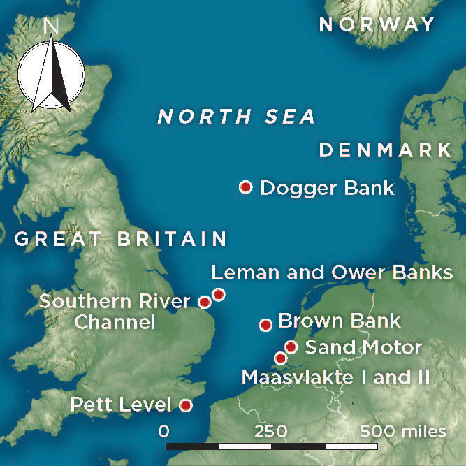 Experts from the British Museum who examined the Colinda harpoon, as it came to be called, determined that it likely dated to the Mesolithic period (10,000–4000 B.C.), the era of the hunter-gathers who lived just before the advent of agriculture. Archaeologists wrestled with the question of how such an object had ended up more than 20 miles offshore at the bottom of the North Sea. It seemed unlikely that prehistoric mariners could have dropped it during a fishing expedition, given the limited long-distance seafaring capabilities they possessed at the time.
 This was an area of the North Sea that was proving particularly bountiful in Mesolithic artifacts. However, Doggerland remained frustratingly inaccessible to archaeologists as the deep, murky waters of the North Sea impeded exploration by divers. By the beginning of the twenty-first century, 70 years after the discovery of the Colinda harpoon, there remained just as many questions about Doggerland as answers. The investigation into it had reached a dead end. “People said, ‘We know there is something out there, but we can’t do anything about it, so let’s move on,’” says University of Bradford archaeologist Vince Gaffney. Doggerland remained tantalizingly close, yet still very far away.
 Before researchers could determine if and where any archaeological sites might have survived within Doggerland, they had to figure out where its people lived. The North Sea basin covers tens of thousands of square miles, stretching from England to Scandinavia. Since it was nearly impossible to formulate an accurate idea of what Doggerland’s landscape looked like when the last Ice Age ended, it was challenging to know where to even begin looking. According to Gaffney, even with all the technology available today, very little is known about Earth’s oceans and seafloors. “We know more about the surface of the moon,” he says.
 The floor of the North Sea is now recognized as the largest well-preserved prehistoric archaeological landscape in the world. It would have been a paradise for the bands of hunter-gatherers who followed the retreating ice sheets into the region to settle there. They, however, were not Doggerland’s first inhabitants. Millennia prior to their arrival, the North Sea basin had belonged to Neanderthals, who lived there for hundreds of thousands of years. During the last Ice Age, between roughly 125,000 and 15,000 years ago, Doggerland was part of the cold and dry mammoth steppe. Because vast quantities of water were trapped in glacial ice sheets, the North Sea was around 450 feet lower than it is today. It was a mostly treeless, grassy plain that attracted mammoths and woolly rhinoceroses as well as herds of reindeer, horses, and aurochs.
 After tens of thousands of years of dramatic shifts in the climate, with alternating warm and cold periods, around 10,000 years ago temperatures began to steadily climb. This marked the end of the Ice Age and ushered in today’s current warm period, known as the Holocene Epoch. As the glaciers melted, water inundated Doggerland, creating rivers, lakes, and marshes. Trees sprouted, growing into forests of pine and birch, and later, oak, hazel, and elm. Mammoths, woolly rhinoceroses, and saber-toothed cats gradually disappeared and were replaced by countless new species. Gone, too, were the Neanderthals. In this blossoming landscape, Mesolithic hunter-gatherers arrived and flourished. “During the Holocene, Doggerland was a wooded environment, but with really extensive coastlines and enormous wetlands. These were the richest areas to live in,” says Amkreutz. “There were forest resources—deer, wild boar, and berries—but also fish, migrating birds, otters, and beavers. It was a Garden of Eden for them, a wetland wonderland.”
 In the nearly a century following the Colinda harpoon’s discovery, fishing vessels have recovered many additional Mesolithic artifacts. Hundreds more have been plucked from beaches in the Netherlands. Over the past 50 years, Dutch authorities have carried out immense land reclamation projects, both to reinforce the sandy barriers of their low-lying coastlines and to expand harbor infrastructure in and around Rotterdam. This has involved extracting massive amounts of sand from the bottom of the North Sea and redistributing it along the Dutch shoreline. During this process, archaeological evidence is sucked up along with the sand and sprayed onto the beaches at places such as Sand Motor and Maasvlakte I and II, where they are then harvested by collectors and brought to the attention of experts such as Amkreutz. “I am sometimes amazed by the sheer number of finds,” he says. “If you assume this is a vast natural landscape, it is quite surprising how many of the objects have been touched or made by human hands.”
 Researchers are now studying the stone, bone, and antler projectile points to learn which materials were preferred and where they were sourced. They are analyzing how these tools were made and hafted, and how they evolved and changed shape over time. The remains of butchered bones suggest how animals were hunted and which species were consumed. Amkreutz and his colleagues are even starting to learn about the people themselves and their behavior. Because the oxygen-free conditions of the North Sea’s deposits preserve organic materials extremely well, they are able to extract DNA from human skeletal remains found on the seafloor. This is providing information about individuals’ sex, age, and physical characteristics, while isotope analysis is producing data about their diet and geographic origins. Some evidence, such as strange postmortem cut marks on human bone fragments, suggests that Doggerland’s Mesolithic people may have even performed rituals on their dead. “We are going to try and squeeze out every bit of information we can from these displaced finds,” Amkreutz says.
 Even though there have been tremendous advances in the study of this lost world in recent years, one element has remained elusive––evidence of the sites where people lived in Doggerland. “We now have a good idea of this landscape,” says Gaffney. “We’ve got the animals and the plants. We have to start looking for the people. It has taken us 15 years, but we are now at the point of being able to prospect a settlement. There is one out there somewhere.”
 But seismic data has now given archaeologists a much better sense of Doggerland’s topography. They know where its rivers, lakes, and coastlines were located, and where its forests were found. They can use this information to speculate about where people may have lived. To Gaffney, the strategy does not deviate much from how he approaches terrestrial landscapes, even though Doggerland lies hundreds of feet underwater. “First we conduct a large-scale assessment, then zoom in on areas of interest,” he says. “I am a landscape archaeologist and I have only ever treated Doggerland as a bit of land. It just happens to be beneath the sea.”
 This new type of research into Doggerland has the potential to once again dramatically alter the field of European prehistory. “We have a completely intact landscape with a state of preservation that we can often only dream of on land,” Amkreutz says. “I think we will have a lot of exciting discoveries to come. We are barely scratching the surface.”
 Over the past century, the story of Doggerland has captured people’s minds and imaginations, as mythological stories about apocalyptic floods and lost worlds often do. But this story is real. “It’s kind of like an Atlantis,” says Amkreutz. “It’s a drowned world, but we have tangible remains coming from it. You can’t see it anymore, but it’s really close.”
 March/April 2024
 January/February 2024
 November/December 2023
 September/October 2023
 July/August 2023
 May/June 2023
 March/April 2023
 January/February 2023
 November/December 2022
 September/October 2022
 July/August 2022
 May/June 2022
 March/April 2022
 January/February 2022
 November/December 2021
 September/October 2021
 July/August 2021
 May/June 2021
 March/April 2021
 January/February 2021
 November/December 2020
 September/October 2020
 July/August 2020
 May/June 2020
 March/April 2020
 January/February 2020
 November/December 2019
 September/October 2019
 July/August 2019
 May/June 2019
 March/April 2019
 January/February 2019
 November/December 2018
 September/October 2018
 July/August 2018
 May/June 2018
 March/April 2018
 January/February 2018
 November/December 2017
 September/October 2017
 July/August 2017
 May/June 2017
 March/April 2017
 January/February 2017
 November/December 2016
 September/October 2016
 July/August 2016
 May/June 2016
 March/April 2016
 January/February 2016
 November/December 2015
 September/October 2015
 July/August 2015
 May/June 2015
 March/April 2015
 January/February 2015
 November/December 2014
 September/October 2014
 July/August 2014
 May/June 2014
 March/April 2014
 January/February 2014
 November/December 2013
 September/October 2013
 July/August 2013
 May/June 2013
 March/April 2013
 January/February 2013
 November/December 2012
 September/October 2012
 July/August 2012
 May/June 2012
 March/April 2012
 January/February 2012
 November/December 2011
 September/October 2011
 July/August 2011
 May/June 2011
 March/April 2011
 January/February 2011

