


From the Trenches


Archaic Engineers Worked on a Deadline
By ERIC A. POWELL
Tuesday, April 30, 2013
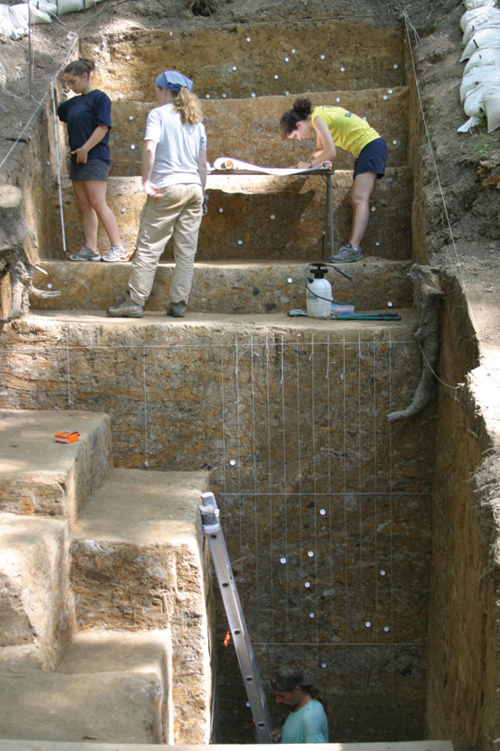 Around 3,200 years ago, hunter-gathers in what is now northern Louisiana managed to construct a series of massive earthworks. Known as Poverty Point, the elaborate site consists of six concentric, arc-shaped ridges surrounded by a number of mounds. The tallest of them, Mound A, now rises 70 feet and seems to be shaped like a bird. Given that a total of one million cubic yards of earth were used to build them, archaeologists have long assumed that the mounds at Poverty Point were built gradually over the course of hundreds of years by successive generations of small bands that came together to celebrate religious rites. But now, Murray State University archaeologist Anthony Ortmann and his colleague Tristram Kidder of Washington University in St. Louis say that while Mound A wasn’t built in a day, it went up in the blink of an eye in archaeological time.
After analyzing the earth that makes up Mound A, the two found no evidence for erosion, which would be expected if the mound were built over the course of centuries. In fact, based on their analysis of the soil, the archaeologists estimate the mound was built in 90 days, or even fewer, and that it took at least 3,000 laborers to construct it. Scholars have long assumed that hunter-gatherers, who had no formal leaders, were so focused on mere survival that they were not capable of quickly building monuments on the scale of Poverty Point. “According to our old model they lacked the organizational abilities,” says Ortmann. “That’s too simplistic, but just how they brought all those people together is still a perplexing question.”
Visions of Valhalla
By JARRETT A. LOBELL
Tuesday, April 30, 2013
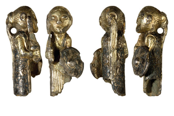 When amateur archaeologist and metal detectorist Morten Skovsby uncovered this tiny silver figurine near the village of Hårby in the southwest part of the Danish island of Funen, he knew exactly what to do. He documented the findspot immediately, and then took the artifact to the City Museum in nearby Odense. When the museum’s curator, Mogens Bo Henriksen, saw the figurine, he knew what it was. “There can hardly be any doubt,” he says, “that this depicts one of Odin’s valkyries.”
Norse myths, called sagas, tell of female figures called valkyries (from the Old Norse valkyrja meaning “chooser of the slain”). The valkyries were sent to battlefields by the god Odin to select which fallen warriors were worthy of afterlives in Valhalla, filled with feasts of wild boar and liquor milked from goats. Despite their prevalence in the sagas, depictions of valkyries are relatively rare. They are confined to Swedish picture stones dating to about A.D. 700 and a handful of Early Viking fibulae (brooches) from Sweden and Denmark. So this three-dimensional representation is unique.
The figurine, which would probably have been a pendant, is partly gilded, while other areas are colored black by niello, a mixture of copper, silver, and lead sulphides used as an inlay. The valkyrie wears a long patterned dress and carries a double-edged Viking sword in her right hand and a shield protecting her body in her left. Dating to about A.D. 800, the figurine was recovered near an excavated area known to have been a metal workshop. Perhaps, says Henriksen, it was discarded as waste. Or maybe it was raw material on the way to the melting pot. “For some unknown reason it didn’t make it that far—and that’s our good luck,” he adds.
Albanian Fresco Fiasco
By JARRETT A. LOBELL
Tuesday, April 30, 2013
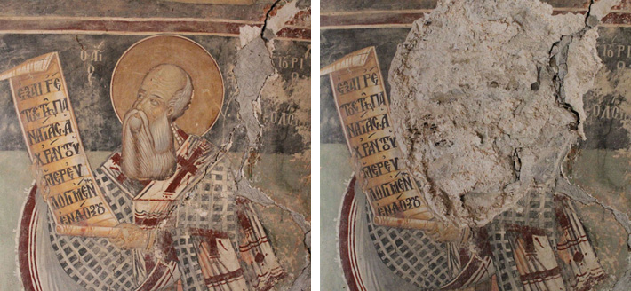
Perhaps it is surprising to find some of the Balkans’ great works of art in the tiny chapel of St. Premte in the remote central Albanian village of Valsh. But the stunning sixteenth-century frescoes were no surprise to the looters who tried to rip them off the walls in two separate attempts on December 30, 2012, and January 4, 2013, causing significant—and some irreversible—damage. Certainly even the partial destruction of any of a nation’s cultural heritage is disturbing. What makes the recent events even more distressing, however, according to Lorenc Bejko, a professor of archaeology and cultural heritage management at the University of Tirana, is that several of the frescoes were painted by Onufri, one of the most important artists of the post-Byzantine period in the southern Balkans.
Onufri was a founder of a school of religious art. He was also a leader of the revival of the style of sacred painting that had flourished two centuries before, during the reigns of the first emperors of the Byzantine Empire’s Palaiologos Dynasty. Although he was a prolific icon painter, and many examples of his icons survive, only a small number of his frescoes are still extant. In fact, in Albania, Onufri’s work can only be seen in Berat, a small city and World Heritage Site in the south-central part of the country, and at Valsh, where the artist resided for a time in the mid-sixteenth century. Other examples of Onufri’s paintings exist outside of modern Albania’s boundaries, at Kastoria in northern Greece and in the Republic of Macedonia. “This makes Onufri particularly important and his works of art, both frescoes and icons, are of special significance for the history of art in the sixteenth and seventeenth centuries,” says Bejko.
 in the Albanian village of Valsh was recently vandalized. It is home to a fresco depicting the saint, which is shown here before (top left) and after (top right) the damage. .") The thieves who came to Valsh this past winter attempted to remove the heads of the saints, but instead succeeded only in damaging the area around St. Ilia’s face and completely destroying the face of St. Premte. Currently the laboratory at the Institute for Cultural Monuments in Tirana is working to reassemble the fresco fragments collected after the attack and scholars there believe that about 30 percent of the figures can be restored. In the meantime, the thieves have not been caught, and Albania, like many countries with such diverse and substantial cultural heritage and without a great deal of funding, struggles to figure out how to protect its sites, museums, and artifacts. “The plundered church at Valsh represents a dramatic loss for the county’s heritage. It was unprecedented and brutal, shocking the conscience of public opinion,” says Bejko. “The local community lost an important resource of pride and income, and Albanian society lost a symbol of its artistic past.”
The thieves who came to Valsh this past winter attempted to remove the heads of the saints, but instead succeeded only in damaging the area around St. Ilia’s face and completely destroying the face of St. Premte. Currently the laboratory at the Institute for Cultural Monuments in Tirana is working to reassemble the fresco fragments collected after the attack and scholars there believe that about 30 percent of the figures can be restored. In the meantime, the thieves have not been caught, and Albania, like many countries with such diverse and substantial cultural heritage and without a great deal of funding, struggles to figure out how to protect its sites, museums, and artifacts. “The plundered church at Valsh represents a dramatic loss for the county’s heritage. It was unprecedented and brutal, shocking the conscience of public opinion,” says Bejko. “The local community lost an important resource of pride and income, and Albanian society lost a symbol of its artistic past.”
Off The Grid
By MALIN GRUNBERG BANYASZ
Tuesday, April 30, 2013
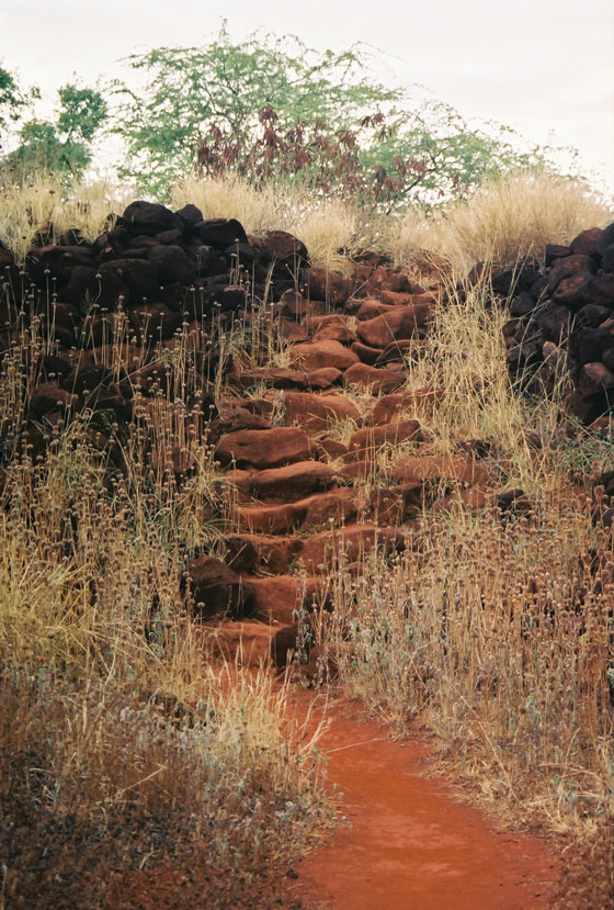 In 1816, Georg Anton Schäffer, a German doctor working for the Russian-American Company, arrived in Hawaii to retrieve company cargo being held by Kaumualii, chief of the island of Kauai. Kaumualii, angling for Russian support to break free from the influence of King Kamehameha (whose kingdom nominally encompassed all the islands), convinced Schäffer that the Russians could capture the entire island chain, and gained Schäffer’s assistance in building a fort on the western side of the island, near Waimea, and two others on the northern side. Schäffer promised Kaumualii the czar’s support—but that support was not his to grant, and a year later Kaumualii forced Schäffer to leave. The Waimea fort, now commonly known as Russian Fort Elizabeth, eventually came under the control of Kamehameha supporters, and years later was used to put down a rebellion by Kaumualii’s son, George “Prince” Humehume. Archaeologist Peter Mills of the University of Hawaii at Hilo says that though Schäffer gave the fort a Western name (for the Empress of Russia at the time), Hawaiians had their own names for it, and built it as an extension of Kaumualii’s residential compound. Its construction recalls Hawaiian-built structures, such as places of worship called heiau.
The site
Russian Fort Elizabeth, a state historical park and a U.S. National Historic Landmark, is situated on the edge of the Waimea River, very close to the Pacific Ocean. A small parking lot off the Kaumualii Highway features a sign with the history of the site and a map of walking trails. Its stacked-stone walls are more than 10 feet thick and enclose one and a half acres. Though it can be difficult to see from ground level, the fort has a star-shaped design typical of European forts of the time but unusual for a Russian colonial structure. While Russian forts were often built of wood, which was available on Kauai, historical accounts of the fort’s construction and stonework leads Mills to infer that it was built not by Russians, but by Hawaiians directed by Kaumualii following Schäffer’s plan. And though many still see the site as a “Russian fort,” it was staffed and guarded exclusively by locals. The site demonstrates the complexities of interpreting multicultural sites from colonial periods, Mills says.
While you’re there
Russian Fort Elizabeth is on the west side of Kauai, which has both cultural sites and scenic wonders. Captain James Cook first landed in Hawaii at Waimea Bay in 1778, and a statue of him stands in Waimea to commemorate the event. The nearby town of Hanapepe is the art capital of Kauai, with many galleries, shops, and restaurants. Amazing views of Kauai’s natural splendor can be seen from Kokee State Park, and from a lookout point above Waimea Canyon, known as the “Grand Canyon of the Pacific.” It stretches 14 miles long, a mile wide, and more than 3,600 feet deep!
Advertisement
Advertisement
IN THIS ISSUE
Features
On the Trail of the Mimbres
Haunt of the Resurrection Men
The Kings of Kent
Letter from Turkey
From the Trenches
Albanian Fresco Fiasco
Off The Grid
Visions of Valhalla
Archaic Engineers Worked on a Deadline
Europe's First Farmers
A Pyramid Fit for a Vizier
Second to Whom?
Thracian Treasure Chest
A Major New Venue
A Killer Bacterium Expands Its Legacy
Bad Monks at St. Stephen's
Hail to the Bождь (Chieftain)
Oops! Down the Drain
From Egyptian Blue to Infrared
Advertisement

Recent Issues
-
May/June 2024
-
 March/April 2024
-
 January/February 2024
-
 November/December 2023
-
 September/October 2023
-
 July/August 2023
-
 May/June 2023
-
 March/April 2023
-
 January/February 2023
-
 November/December 2022
-
 September/October 2022
-
 July/August 2022
-
 May/June 2022
-
 March/April 2022
-
 January/February 2022
-
 November/December 2021
-
 September/October 2021
-
 July/August 2021
-
 May/June 2021
-
 March/April 2021
-
 January/February 2021
-
 November/December 2020
-
 September/October 2020
-
 July/August 2020
-
 May/June 2020
-
 March/April 2020
-
 January/February 2020
-
 November/December 2019
-
 September/October 2019
-
 July/August 2019
-
 May/June 2019
-
 March/April 2019
-
 January/February 2019
-
 November/December 2018
-
 September/October 2018
-
 July/August 2018
-
 May/June 2018
-
 March/April 2018
-
 January/February 2018
-
 November/December 2017
-
 September/October 2017
-
 July/August 2017
-
 May/June 2017
-
 March/April 2017
-
 January/February 2017
-
 November/December 2016
-
 September/October 2016
-
 July/August 2016
-
 May/June 2016
-
 March/April 2016
-
 January/February 2016
-
 November/December 2015
-
 September/October 2015
-
 July/August 2015
-
 May/June 2015
-
 March/April 2015
-
 January/February 2015
-
 November/December 2014
-
 September/October 2014
-
 July/August 2014
-
 May/June 2014
-
 March/April 2014
-
 January/February 2014
-
 November/December 2013
-
 September/October 2013
-
 July/August 2013
-
 May/June 2013
-
 March/April 2013
-
 January/February 2013
-
 November/December 2012
-
 September/October 2012
-
 July/August 2012
-
 May/June 2012
-
 March/April 2012
-
 January/February 2012
-
 November/December 2011
-
 September/October 2011
-
 July/August 2011
-
 May/June 2011
-
 March/April 2011
-
 January/February 2011
Advertisement

