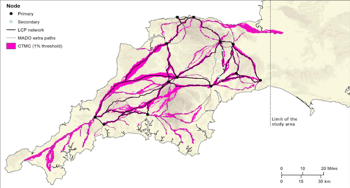
EXETER, ENGLAND—According to a statement released by the University of Exeter, Christopher Smart and João Fonte from the University of Exeter and César Parcero Oubiña of the Spanish National Research Council used lidar laser scans and predictive geographical modeling techniques to map a previously unknown network of Roman roads in southwestern England. The researchers began the model with the locations of known military fortifications and the settlements at what are now Exeter and North Tawton, a small town on the River Taw in the center of the county of Devon. The researchers then calculated the easiest routes between these points, and compared them to the lidar scans of the counties of Devon and Cornwall. The study resulted in the identification of an additional eight miles of Roman roads, found within a short distance of the routes predicted by the model. The researchers also used the model to predict the locations of some secondary and tertiary routes likely used by the Romans for the transport of supplies. “In terms of chronology, it is likely that the proposed network is an amalgam of pre-existing prehistoric routeways, Roman military campaign roads or ‘tactical roads’ formally adopted in to the provincial communications system, and of those constructed during peacetime in a wholly civilian context,” Fonte explained. Read the original scholarly article about this research in Journal of Computer Applications in Archaeology. To read about excavations of Roman farmsteads in Cambridgeshire, go to "Letter from England: Building a Road Through History."