


High-Tech Map Made of Scottish Islands

Tuesday, February 5, 2019
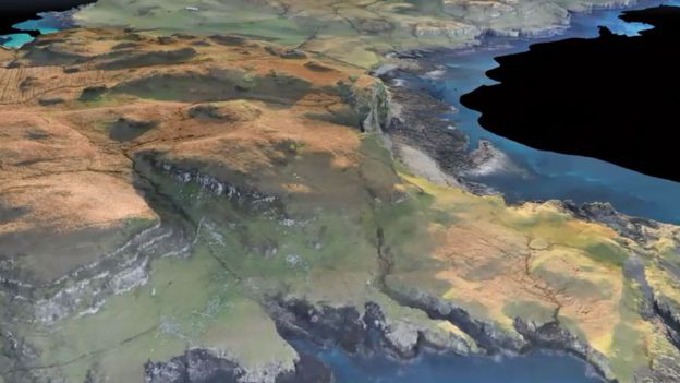 GLASGOW, SCOTLAND—BBC News reports that more than 4,000 photographs of Canna and Sanday, islands in the Scottish Inner Hebrides, were taken with an ultra-high-definition camera on a fixed-wing drone. Researchers from the National Trust for Scotland said the resulting minutely detailed 3-D map, which was produced by the firm GeoGeo, revealed dozens of archaeological sites dating from the Neolithic and Bronze Age through the nineteenth century. The sites include settlement mounds, hut circles, and shielings, or rough shelters placed in pastures. “We’ve been able to obtain exact plots of known sites but also recorded the extensive traces of cultivation, such as rig and furrow field systems that range in age from the Bronze Age onwards,” explained Derek Alexander of the National Trust for Scotland. To read about an unusual discovery in the Scottish Outer Hebrides, go to “Scottish 'Frankenstein' Mummies.”
Advertisement
IN THE CURRENT ISSUE
Digs & Discoveries
Ancient Egyptian Caregivers
Educational Idols
Cleaning Out the Basement
Pompeian Politics
Near Eastern Lip Kit
Turn of the Millennium Falcon
Speaking in Golden Tongues
Workhouse Woes
Hunting Heads
The Amazon’s Urban Roots
Off the Grid
Around the World
Panama’s golden grave, Viking dental exams, an unusual papyrus preservative, playing games in ancient Kenya, and a venerable Venetian church
Artifact
Within a knight’s grasp
Advertisement

Recent Issues
-
May/June 2024
-
 March/April 2024
-
 January/February 2024
-
 November/December 2023
-
 September/October 2023
-
 July/August 2023
-
 May/June 2023
-
 March/April 2023
-
 January/February 2023
-
 November/December 2022
-
 September/October 2022
-
 July/August 2022
-
 May/June 2022
-
 March/April 2022
-
 January/February 2022
-
 November/December 2021
-
 September/October 2021
-
 July/August 2021
-
 May/June 2021
-
 March/April 2021
-
 January/February 2021
-
 November/December 2020
-
 September/October 2020
-
 July/August 2020
-
 May/June 2020
-
 March/April 2020
-
 January/February 2020
-
 November/December 2019
-
 September/October 2019
-
 July/August 2019
-
 May/June 2019
-
 March/April 2019
-
 January/February 2019
-
 November/December 2018
-
 September/October 2018
-
 July/August 2018
-
 May/June 2018
-
 March/April 2018
-
 January/February 2018
-
 November/December 2017
-
 September/October 2017
-
 July/August 2017
-
 May/June 2017
-
 March/April 2017
-
 January/February 2017
-
 November/December 2016
-
 September/October 2016
-
 July/August 2016
-
 May/June 2016
-
 March/April 2016
-
 January/February 2016
-
 November/December 2015
-
 September/October 2015
-
 July/August 2015
-
 May/June 2015
-
 March/April 2015
-
 January/February 2015
-
 November/December 2014
-
 September/October 2014
-
 July/August 2014
-
 May/June 2014
-
 March/April 2014
-
 January/February 2014
-
 November/December 2013
-
 September/October 2013
-
 July/August 2013
-
 May/June 2013
-
 March/April 2013
-
 January/February 2013
-
 November/December 2012
-
 September/October 2012
-
 July/August 2012
-
 May/June 2012
-
 March/April 2012
-
 January/February 2012
-
 November/December 2011
-
 September/October 2011
-
 July/August 2011
-
 May/June 2011
-
 March/April 2011
-
 January/February 2011
Advertisement

