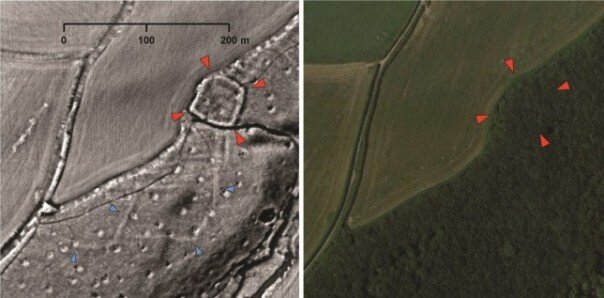
EXETER, ENGLAND—The Guardian reports that eight volunteers working with landscape archaeologist Chris Smart of the University of Exeter have spotted 30 previously unknown Roman settlements, more than 200 miles of roads, 20 prehistoric burial mounds, and hundreds of medieval farms in highly detailed lidar scans of southwest Britain’s Tamar Valley. “I knew we’d find some things but I didn’t think it would be so many,” Smart said. The ancient roads, which probably connected Roman military forts, appear as faint white marks in the aerial images. Nearby black dots are thought to have been quarry pits. “We’re seeing a much greater density of population than we thought,” Smart added. The locations of the possible archaeological sites are being kept confidential for now, but will be investigated in the future. To read about how aerial laser scanning and other remote sensing methods were used to identify new monuments on England's Salisbury Plain, go to "Under Stonehenge," one of ARCHAEOLOGY's Top 10 Discoveries of 2014.