


Features


Castaways
By SAMIR S. PATEL
Monday, September 15, 2014

On the night of July 31, 1761, Jean de Lafargue, captain of the French East India Company ship L’Utile (“Useful”), was likely thinking of riches. In the ship’s hold were approximately 160 slaves purchased in Madagascar just days before and bound for Île de France, known today as Mauritius. It had been 80 years since the dodo had gone extinct on that Indian Ocean island, and the thriving French colony had a plantation economy in need of labor. However, though slavery was legal at the time, de Lafargue was not authorized by colonial authorities to trade in slaves.
According to the detailed account of the ship’s écrivain, or purser, as L’Utile approached the vicinity of an islet then called Île des Sables, or Sandy Island, winds kicked up to 15 or 20 knots. The ship’s two maps did not agree on the small island’s precise location, and a more prudent captain probably would have slowed and waited for daylight. But de Lafargue was in a hurry to reap his bounty. That night L’Utile struck the reef off the islet’s north end, shattering the hull. Most of the slaves, trapped in the cargo holds, drowned, though some escaped as the ship broke apart. The next morning, 123 of the 140 members of the French crew and somewhere between 60 and 80 Malagasy slaves found themselves stranded on Île des Sables—shaken and injured, but alive.
De Lafargue had some kind of nervous breakdown, according to the écrivain. First officer Barthélémy Castellan du Vernet took over, and rallied the crew to salvage food, tools, and timber from the wreck and build separate camps for the crew and the slaves. Under the first officer’s guidance, a well was dug, an oven and furnace built, and work on a new boat begun. Within two months, the makeshift vessel La Providence emerged from the remains of L’Utile. Du Vernet, before he sailed away with the crew, promised the Malagasy people that a ship would return for them. And so they waited. The few that survived waited a very long time.
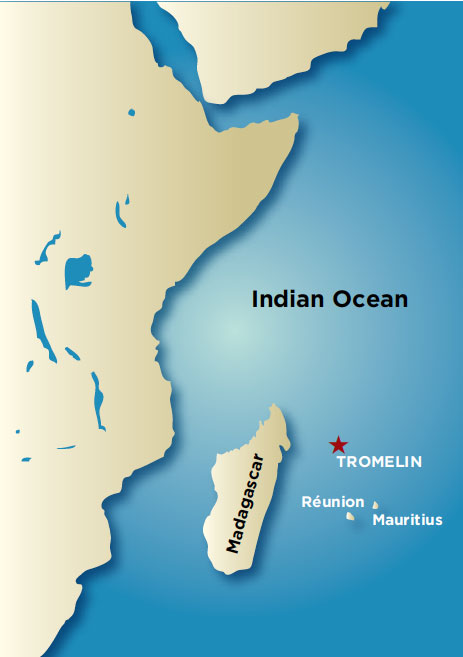 The islet, today called Tromelin Island, lies 300 miles east of Madagascar and 350 miles north of Mauritius. Shaped like a sunflower seed, it is just one-third of a square mile of sand and scrub. Today it hosts an unpaved runway, a staffed weather station, and a wildlife preserve. Hermit crabs swarm across the island in packs at night, and each year hundreds of sea turtles and countless birds arrive to lay their eggs.
Diaries, letters, and the écrivain’s account document the wreck and the two months that the French crew stayed on the island, but the Malagasy castaways left no written records. Their story would have remained almost completely untold but for Max Guérout, a former French navy officer. Guérout had captained an underwater research vessel in the late 1970s, and upon his retirement in the early 1980s founded the Naval Archaeology Research Group (known by its French acronym, GRAN), which has since studied dozens of postmedieval shipwrecks. He heard the Tromelin story from a colleague and, with support from UNESCO, began two years of archival research in 2004. “The history was so interesting that we decided to make an archaeological survey,” he says. Guérout built a team, which included experts from GRAN, the French National Institute of Preventive Archaeological Research (INRAP), and the administration of the French Southern and Antarctic Lands, to travel to the isolated islet four times—2006, 2008, 2010, and 2013—for six weeks at a stretch to examine the wreck site, excavate, and learn something about the lives of the Malagasy castaways, lives undocumented by history.

 That year, the team also found six copper plates or bowls. These items had clearly been salvaged from the wreck, and then possibly hammered into new shapes. More remarkable was how they had been repaired—some up to eight times—over the course of 15 years. “To repair a copper plate is not so easy,” says Guérout. The castaways had to cut pieces of copper from other objects for patches, drill holes through both patches and plates, and then use small rolled pieces of copper as rivets, which they then hammered into place. The repairs are reflections of patience and industry, and reminders of the passage of time.
 A detailed analysis of some 18,000 bird bones collected from the site during the 2013 season has revealed much about the castaways’ diet. Most of the bones come from sooty terns. These seabirds once nested on the island in great numbers, but not anymore—hunting by the survivors may have contributed to the colony’s collapse. The castaways also ate bird eggs and some fish, though fishing from the island is difficult, as well as turtle meat, even though killing and eating turtles is taboo to some Malagasy communities, according to Bako Rasoarifetra, a Malagasy historian from the University of Antananarivo who joined the 2010 and 2013 expeditions.
 A few small pieces of copper jewelry—a ring, a couple of bracelets, and an eighteenth-century Portuguese coin that may have been worn as a pendant—were also found, along with a pointe-démêloir, or tip-comb, for untangling hair. Slaves usually had their hair cut short, but the castaways would have been able to grow their hair out again. Traditionally, Rasoarifetra adds, a man would make a pointe-démêloir for the woman he loved. These small, personal finds suggest that at some point in their stay, the castaways came to the realization that there would be no rescue and they would have to build lives—a community—on the island. “They have passed the time of strictly surviving and they begin to live a ‘normal’ life,” Guérout says.
America, in the Beginning
By NIKHIL SWAMINATHAN
Monday, August 11, 2014
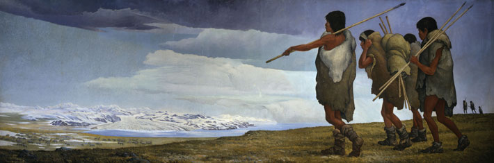
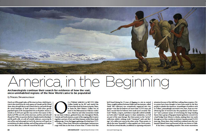
Nearly one billion people today call the Americas home, inhabiting territories that stretch from the wide expanses of Canada and the United States, down through Mexico and Central America, and south through the varied landscapes of South America to Chile—from sparsely populated regions to some of the most crowded cities on the planet. And yet, as recently as 16,000 years ago, there may not have been anyone in these lands at all. Who were the earliest Americans, and how and when did they get here? These are questions that have long fascinated archaeologists and the public alike. As with all scientific endeavors, uncovering the story of how and when people arrived in the Americas will require an accumulation of evidence and data, and will long continue to be subject to revision. Here, then, is where the research has led so far:
Erbil Revealed
By ANDREW LAWLER
Monday, August 11, 2014
 in Kurdistan encircles the ancient citadel where evidence of more than six millennia of human habitation is just beginning to be uncovered.")
The 100-foot-high, oval-shaped citadel of Erbil towers high above the northern Mesopotamian plain, within sight of the Zagros Mountains that lead to the Iranian plateau. The massive mound, with its vertiginous man-made slope, built up by its inhabitants over at least the last 6,000 years, is the heart of what may be the world’s oldest continuously occupied settlement. At various times over its long history, the city has been a pilgrimage site dedicated to a great goddess, a prosperous trading center, a town on the frontier of several empires, and a rebel stronghold.
Yet despite its place as one of the ancient Near East’s most significant cities, Erbil’s past has been largely hidden. A dense concentration of nineteenth- and twentieth-century houses stands atop the mound, and these have long prevented archaeologists from exploring the city’s older layers. As a consequence, almost everything known about the metropolis—called Arbela in antiquity—has been cobbled together from a handful of ancient texts and artifacts unearthed at other sites. “We know Arbela existed, but without excavating the site, all else is a hypothesis,” says University of Cambridge archaeologist John MacGinnis.
Last year, for the first time, major excavations began on the north edge of the enormous hill, revealing the first traces of the fabled city. Ground-penetrating radar recently detected two large stone structures below the citadel’s center that may be the remains of a renowned temple dedicated to Ishtar, the goddess of love and war. There, according to ancient texts, Assyrian kings sought divine guidance, and Alexander the Great assumed the title of King of Asia in 331 B.C. Other new work includes the search for a massive fortification wall surrounding the ancient lower town and citadel, excavation of an impressive tomb just north of the citadel likely dating to the seventh century B.C., and examination of what lies under the modern city’s expanding suburbs. Taken together, these finds are beginning to provide a more complete picture not only of Arbela’s own story, but also of the growth of the first cities, the rise of the mighty Assyrian Empire, and the tenacity of an ethnically diverse urban center that has endured for more than six millennia.
Located on a fertile plain that supports rain-fed agriculture, Erbil and its surrounds have, for thousands of years, been a regional breadbasket, a natural gateway to the east, and a key junction on the road connecting the Persian Gulf to the south with Anatolia to the north. Geography has been both the city’s blessing and curse in this perennially fractious region. Inhabitants fought repeated invasions by the soldiers of the Sumerian capital of Ur 4,000 years ago, witnessed three Roman emperors attack the Persians, and suffered the onslaught of Genghis Khan’s cavalry in the thirteenth century, the cannons of eighteenth-century Afghan warlords, and the wrath of Saddam Hussein’s tanks only 20 years ago. Yet, through thousands of years, the city survived, and even thrived, while other once-great cities such as Babylon and Nineveh crumbled.
 Today Erbil is the capital of Iraq’s autonomous province of Kurdistan. The citadel remains at the heart of a thriving city with a population of 1.3 million, made up mostly of Kurds, and a boomtown economy, thanks to a combination of tight security and oil wealth. During the twentieth century, the high mound fell into disrepair as refugees from the region’s conflicts replaced the town’s established wealthy families, who moved to more spacious accommodations in the lower town and suburbs below. The refugees have since moved to new settlements, and efforts are currently under way to renovate the deteriorating nineteenth- and twentieth-century mudbrick dwellings and twisting, narrow alleys. A textile museum opened in a restored, grand, century-old mansion in early 2014, and work rebuilding the adjacent nineteenth-century Ottoman gate, which sits on much more ancient foundations, is nearing completion. The conservation work is also giving archaeologists the chance to dig into the mound—which has just been declared a World Heritage Site—once so wholly inaccessible. “Erbil has been largely neglected, and we know so little,” says archaeologist Karel Novacek of the University of West Bohemia in the Czech Republic, who conducted the first limited excavations on the citadel in 2006. Extensive long-term excavations are not feasible in Erbil. Nevertheless, Novacek, MacGinnis, their Iraqi colleagues, and archaeologists from Italy, France, Greece, Germany, and the United States, are using old aerial photographs, Cold War satellite imagery, and archives of ancient cuneiform tablets to pinpoint the best spots to dig in order to take advantage of this first real opportunity to examine Erbil’s past.
 strategic location between the great Assyrian cities to the west and south, and the Zagros Mountains to the east, placed it at the heart of the ancient Near East’s most important cities and empires.")
 At the core of Arbela’s religious, political, and economic life in this period was the Egasankalamma, or “House of the Lady of the Land.” Assyrian texts mention the temple, dedicated to Ishtar, as early as the thirteenth century B.C., though its foundations likely rest on even older sacred structures. In Mesopotamian theology Ishtar was the goddess of love, fertility, and war. Martti Nissinen of the University of Helsinki has closely examined the 265 references to the goddess in Assyrian texts, and he suggests that the roots of this version of Ishtar may lay deep in the ancient Hurrian pantheon.
 Under the Assyrians, Arbela was a cosmopolitan gathering place for foreign ambassadors coming from the east. “Tribute enters it from all the world!” says Ashurbanipal in one text. A governor oversaw the city’s administration from a sumptuous citadel palace where taxpayers brought copper and cattle, pomegranates, pistachios, grain, and grapes. Arbela’s own inhabitants were a diverse mix that likely included those forcibly resettled by the Assyrian state, as well as immigrants, merchants, and others seeking opportunity in a city that rivaled the Assyrian capitals in stature. “Arbela at this time was a multiethnic state,” says Dishad Marf, a scholar at the Netherlands’ Leiden University. Names of its citizens found in Assyrian texts are Babylonian, Assyrian, Hurrian, Aramain, Shubrian, Scythian, and Palestinian.
 After so many centuries of regional domination, the Assyrians’ fall was sudden and swift—and Arbela proved to be the sole surviving major settlement. A coalition of Babylonians and Medes, a nomadic people who lived on the Iranian plateau, destroyed the Assyrian capitals in 612 B.C. and scattered their once-feared armies. Arbela was spared, perhaps because its population was in large part non-Assyrian and sympathetic to the new conquerors. The Medes, who may be the ancestors of today’s Kurds, likely took control of the city, which was still intact a century later when the Persian king Darius I, third king of the Achaemenid Empire, impaled a rebel on Arbela’s ramparts—a scene recorded in an inscription carved on a western Iranian cliff around 500 B.C.
 Novacek, meanwhile, has turned his attention to the ancient city that grew up in the citadel’s shadow. “The lower town, which has been barely investigated, is the key to understanding the city’s dynamics,” he says. “Digging there requires a different approach.” Today Erbil’s thickly settled downtown, in fact, hides traces of the ancient site. Novacek is using British Royal Air Force aerial photos taken in the 1950s and American spy satellite images from the 1960s Corona program to look for remnants of the ancient city that survived into at least the middle of the twentieth century. He has found faint outlines of two sets of fortifications. One of these is a modest system probably dating from the medieval era, while the second is a much larger set of structures that likely dates to some time in the Assyrian period, and had been bulldozed to make way for the modern town in the 1960s.
 The earlier fortifications include a 60-foot-thick wall that likely had a defensive slope and a moat. The city’s formidable construction, says Novacek, resembles that found at Nineveh and Assur, and places it “unambiguously among Mesopotamian mega-cities.” The layout differs from that in other Assyrian cities, where the walls were rectangular, with a citadel as part of the protective fortifications. Arbela, however, had an irregular round wall entirely enclosing both the citadel and the lower town. That design is more typical of ancient southern Mesopotamian cities such as Ur and Uruk—a hint, Novacek says, of Erbil’s ancient urban heritage. “This conjecture desperately needs empirical verification,” he cautions. Yet, if it can be proven, ancient Arbela might rank among the earliest urban areas and challenge the idea that urbanism began solely in southern Mesopotamia.
 The ongoing research of the teams now working in the city is starting to create an archaeological picture of life in Erbil and its environs over the course of millennia. After the Assyrians, Persians, and Greeks were gone, the city went on to serve as a key eastern outpost on the Roman frontier, and was briefly the capital of the Roman province of Assyria. Later it was home to flourishing Christian and Zoroastrian communities under Persian Sasanian rule until the arrival of Islam in the seventh century A.D. Though the city escaped destruction by the Mongols in the thirteenth century—its leaders wisely negotiated surrender—Erbil subsequently slipped into obscurity. When Western explorers arrived in the eighteenth century they dismissed the place as a muddy and decrepit settlement of medieval origin. While Kurdistan’s isolation under the latter part of Saddam Hussein’s reign placed the area off-limits to most outsiders, in the post-Saddam era, Erbil has been set to play an important role in the region. Conflict, however, threatens again.
Advertisement
DEPARTMENTS
Also in this Issue:
Advertisement
IN THIS ISSUE
From the Trenches
Your Face: Punching Bag or Spandrel?
Off the Grid
Sounds of the Age of Aquarius
Conquest and Clamshells
They're Just Like Us
Modern-Day Ruin
World's Oldest Pants
Off With Their Heads
Alone, but Closely Watched
Saving the Golden House
The Dovedale Hoard
An Ancient Andean Homecoming
Dawn of a Disease
The Case of the Missing Incisors
Advertisement

Recent Issues
-
May/June 2024
-
 March/April 2024
-
 January/February 2024
-
 November/December 2023
-
 September/October 2023
-
 July/August 2023
-
 May/June 2023
-
 March/April 2023
-
 January/February 2023
-
 November/December 2022
-
 September/October 2022
-
 July/August 2022
-
 May/June 2022
-
 March/April 2022
-
 January/February 2022
-
 November/December 2021
-
 September/October 2021
-
 July/August 2021
-
 May/June 2021
-
 March/April 2021
-
 January/February 2021
-
 November/December 2020
-
 September/October 2020
-
 July/August 2020
-
 May/June 2020
-
 March/April 2020
-
 January/February 2020
-
 November/December 2019
-
 September/October 2019
-
 July/August 2019
-
 May/June 2019
-
 March/April 2019
-
 January/February 2019
-
 November/December 2018
-
 September/October 2018
-
 July/August 2018
-
 May/June 2018
-
 March/April 2018
-
 January/February 2018
-
 November/December 2017
-
 September/October 2017
-
 July/August 2017
-
 May/June 2017
-
 March/April 2017
-
 January/February 2017
-
 November/December 2016
-
 September/October 2016
-
 July/August 2016
-
 May/June 2016
-
 March/April 2016
-
 January/February 2016
-
 November/December 2015
-
 September/October 2015
-
 July/August 2015
-
 May/June 2015
-
 March/April 2015
-
 January/February 2015
-
 November/December 2014
-
 September/October 2014
-
 July/August 2014
-
 May/June 2014
-
 March/April 2014
-
 January/February 2014
-
 November/December 2013
-
 September/October 2013
-
 July/August 2013
-
 May/June 2013
-
 March/April 2013
-
 January/February 2013
-
 November/December 2012
-
 September/October 2012
-
 July/August 2012
-
 May/June 2012
-
 March/April 2012
-
 January/February 2012
-
 November/December 2011
-
 September/October 2011
-
 July/August 2011
-
 May/June 2011
-
 March/April 2011
-
 January/February 2011
Advertisement

