Hydraulic engineering was the key to winning the hearts and minds of a conquered people
By JULIAN SMITH
Wednesday, December 19, 2012
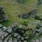
Tamara Bray of Wayne State University walks through a municipal lot in a suburb of the colonial city of Ibarra, in the Andean highlands of northern Ecuador. At 7,550 feet on the northern slope of Imbabura Volcano, the equatorial sun has an intensity that burns through the occasional cool breeze. Chickens peck in the dirt and we can hear children playing at a school nearby. As we walk through the lot, which is now an archaeological site called Inca-Caranqui, Bray explains that the local people knew this was an ancient settlement long before the first archaeological surveys in the late 1990s. Just across the street stand two walls—one 130 feet long and the other 165—that were built by the Inca. One wall has traces of three trapezoidal doorways with remnants of plaster and pigments.
Ecuadorian archaeologist José Echeverría leads us through the site, down a winding path that follows the low outlines of partially excavated walls. He explains that, in 2006, he was helping clear debris left over from a brickmaking operation when he uncovered some Inca masonry at the east end of the site, which turned out to be part of a large ceremonial pool about 33 by 55 feet in size. It was dug to a depth of four to five feet below the modern ground level and was surrounded by walls about three feet high. The walls and floor were made of finely cut and fitted stone.
Bray and Echeverría believe the pool may date to a period in the early 1500s, shortly after the Inca ruler Huayna Capac had concluded a 10-year war of conquest against the local people, the Caranqui. Legend has it that Huayna Capac had every adult male Caranqui executed. Their bodies were thrown into a lake known today as Yahuarcocha, or the “Lake of Blood,” on Ibarra’s northeast edge. Spanish chronicler Pedro Cieza de León estimated the conflict left 20,000 to 50,000 Caranqui dead.
Bray and Echeverría think that in the aftermath of that bloodshed, the Inca built the pool as part of a construction project that was meant to demonstrate their power to their new Caranqui subjects. The ceremonial pool would have represented a considerable investment of wealth and labor by the Inca. It also would have showed their skill as engineers by bringing water from as far as five and a half miles away and demonstrated their mastery over a resource with powerful religious symbolism.
Sidebar:
Machu Picchu's
Stairway of
Fountains
The Caranqui are best known for the dozens of large earthen mounds called tolas they built between A.D. 1200 and 1500. The Inca ceremonial pool was built next to the central part of a Caranqui settlement that had been about 25 acres in size. Radiocarbon dates from the site show that it was occupied on two occasions with a long period of abandonment in between. Dates from several burials indicate that an unknown group of people first lived at the site sometime between 40 B.C. and A.D. 80. One of the burials held the remains of a woman over the age of 40, who Bray believes was an important person because she was buried seated upright with a shell-bead necklace, two folded gold discs, and a large ceramic dish. The Caranqui themselves probably occupied the site around A.D. 1250 and continued there until sometime between 1420 and 1480, a date that came from a radiocarbon sample associated with an Inca wall. These dates generally correspond with the time other Inca sites in the northern part of their empire were being settled. Only a small handful of Inca ceramics have turned up, which, Bray says, is one indicator that they weren’t here long.
Cieza de León, the first Spanish chronicler to visit the site in person, wrote in the late 1540s that “even though [the site] is in total ruins today, one can see that it was a grand place in former times.” He described royal palaces and dwellings made of “large, elegantly cut, and subtly fitted stones.” Among these was a fine estanque (“pool”) made of piedra muy prima (“the finest stone”).
Bray and Echeverría think they have found the estanque Cieza de León recorded. “We call it the ‘Templo de Agua’—the Water Temple,” Bray says. “You find pools at almost every Inca site, but they’re usually 10 or 20 square feet—nothing like this.” Only three or four sites in Ecuador have this kind of Inca masonry, which seems to have been reserved for palaces and temples, she says. “We don’t know if it was intended to hold water for any significant amount of time or not, but it was clearly built for the circulation of water and people,” she adds, referring to the water channels and the sets of steps in each corner of the pool.
Two distinct styles of canals run through the lot and into the pool. The larger type was lined and capped with roughly worked stone. The other was made of stone blocks 20 to 30 inches long laid end to end, each with a grooved channel carved into it. Bray points out various features to explain how they think the water circulated. Streams from the slopes of Imbabura, five and a half miles away, were directed to the site through canals and emptied into the pool through a series of spouts on the south side and a carved stone canal on the east. The water would have drained through two carved holes and into an underground canal, also on the east side.
Spanish chroniclers disagree over which Inca ruler built these structures and why. One Spaniard, Fernando de Montesinos, says that it was Huayna Capac, who then departed for Cuzco but left behind his two-year-old son, Atahualpa, to be raised by Inca authorities. Another, Juan de Betanzos, says Atahualpa himself ordered the construction to commemorate his father, who died of smallpox around 1527, and to celebrate his upcoming wedding and ascension to the throne.
Sidebar:
Machu Picchu's
Stairway of
Fountains
Bray thinks that each explanation may be partly correct, noting that the pool apparently went through two periods of construction. Echeverría points out a large area where flooring stones had apparently been removed down to the underlying soil. At the edge of this section, two levels of flooring are clearly visible: a lower level made of rectangular blocks, and an upper level of smaller, more polygonal stones.
“I think Huayna Capac built the site, and then Atahualpa remodeled it for his coronation,” says Bray. Every new Inca ruler traditionally founded an estate for his royal lineage and Bray believes that may have been Atahualpa’s intention at Inca-Caranqui. The new floor level would have been part of Atahualpa’s remodeling. It could also have been to correct some kind of functional problem, she admits. Either way, she says, it was probably the last major Inca construction project. In 1532, the Spanish under Francisco Pizarro arrived just as Atahualpa defeated his half-brother Huascar in a civil war. Within a year, Atahualpa had been executed and the Spanish conquest was well under way.
As architecturally impressive as the site is, Bray says, it’s hard to overstate its symbolic importance. “Manipulating water was clearly a huge deal to the Inca. They’re manifesting physical control and power over an important local resource.”
Controlling water was essential, says Carolyn Dean of the University of California, Santa Cruz, because either too little or too much could be disastrous to crops. As a result, hydraulic features were common in Inca architecture, and many of them balanced practical, aesthetic, and symbolic elements. They were drawing on thousands of years of previous experience, says Charles Ortloff, a hydraulic engineer specializing in ancient water systems. Earlier cultures such as the Wari, Chimú, and Tiwanaku were experts in manipulating water in a land with few reliable sources and regular climatic extremes, from El Niño events to centuries-long droughts.
“It’s really impressive, what the Inca did without iron, steel, or written language,” says Ken Wright, a hydraulic engineer who has studied Inca water control techniques. “They did so much with so little, it’s just miraculous,” he says. The Inca came to power in a period of increasing precipitation, after a drought that lasted roughly from A.D. 950 to 1200. They took earlier techniques and raised them to new levels of technical and aesthetic sophistication, Wright says. Agricultural terraces were fed by long canal systems, optimized to carry certain flow rates and prevent washout after excessive rainfall.
“They were absolute experts in elaborating the natural world in a way that made the water both useful and ritual,” says Jerry Fairley of the University of Idaho. He adds that the Inca had developed a system of groundwater storage at settlements such as Tipón and Tambomachay near Cuzco, where walls were built at the bottom of geologic basins to hold back groundwater in the soil itself. The water could then be discharged through an opening in the wall.
Sidebar:
Machu Picchu's
Stairway of
Fountains
All these features were fed and drained by channels or canals that ranged from a few inches to many feet wide, he explains. They could be covered or open, above- or belowground, straight or curved or zigzagged. As they split apart and joined together, Dean believes, the canal networks followed the Inca principles of p’allqa (“division”) and tinku (“joining”), concepts at the core of their view of the universe as a balance of complementary forces.
Water was a sacred natural force to the Inca, Dean says, adding, “to manage water, to ensure its availability and control its amount, was to manage the essence of life.” In the Inca view, all water came from a single source called Mama Qucha, embodied by the ocean and large lakes. It circulated in a continuous cycle between the underworld, the earth’s surface, the atmosphere, and the heavens, where the Milky Way was seen as a giant river.
The Inca considered some natural springs to be sacred places of ancestral emergence, mirrored by the water itself coming to the surface, Dean says. The Inca often enhanced these natural sources with fine stonework such as spouts and pools in places such as the 500-acre royal estate of Tipón. “Display fountains” in prominent locations were designed to appeal to the senses with the sight and sounds of water flowing through channels and over steps or terraces. Reservoirs, holding tanks, and cisterns arranged throughout the site helped regulate flow. Some of these features probably served as basins or baths, places of ritual purification and cleansing, a common practice in the Andes in pre-Hispanic times, according to Dean.
There was also a definite political element to Inca water architecture. “The idea is to impress the hell out of the natives,” says Gordon McEwan of Wagner College. This may have been an especially important task in new territories at the edges of the empire. “The Inca were saying, ‘Our emperor is a demigod, and we control the most important things in life: fertility and water.’” The area that is now Ecuador was very rebellious, Dean explains, and places such as Inca-Caranqui showed what the new overlords had to offer, both technologically and culturally.
According to Dean, the Inca believed they were bringing civilization to less developed regions. “Part of any Inca ruler’s reputation was his ability to increase his territory as a warrior,” Dean says. “But equally important—and I think even more so—was his ability to make that newly acquired land even more productive than it had been. Destruction only takes you so far. Afterward, the really important part was to create things.”
Julian Smith is a contributing editor at ARCHAEOLOGY.
One thousand years of spirituality, innovation, and social development emerge from a ceremonial center on the Scottish archipelago of Orkney
By KATE RAVILIOUS
Thursday, March 19, 2015
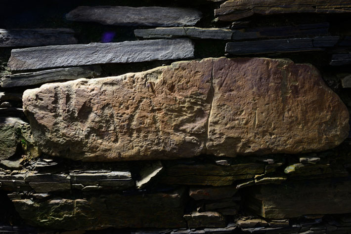
In 2002, Ola and Arnie Tait decided they wanted to change the view from their kitchen window. Rather than staring at a sheep pasture, they envisioned looking out onto a wildflower meadow full of poppies, cornflowers, buttercups, and singing birds. Their farm, on Orkney, a remote archipelago of 70 islands 10 miles off the north coast of Scotland, sits in a stunning natural setting, on a narrow strip of land between two sparkling lochs, and is equidistant from two of the most significant Neolithic stone circle monuments: the Standing Stones of Stenness and the Ring of Brodgar, each less than a mile away. In 2003, the Taits plowed their field in preparation for planting that meadow. Just as they rounded the last bend, the plow brought up a surprise: a notched slab of stone. They showed the find to Orkney’s regional archaeologist, Julie Gibson, who thought it might be a side panel from a Bronze Age stone coffin. “This find implied that there were human remains under the field, so a test trench was opened,” says Roy Towers, an archaeologist at the Orkney campus of the University of the Highlands and Islands.
Years have passed and the Taits are still not looking at their wildflower meadow. Rather, they have a prime view of one of the most spectacular Neolithic ceremonial complexes ever discovered. Spanning a millennium of activity beginning around 5,000 years ago, these exquisitely preserved buildings, including foundations and low walls, are revealing how Neolithic society changed over time, and why Orkney—despite its seemingly remote location—was at the center of Neolithic Europe. “Thank goodness the Taits didn’t use a deep plow, or else we’d have been looking at a pile of rubble,” says Towers.
Instead of digging up a Bronze Age coffin in the 2003 test trench, as they expected, the archaeologists uncovered part of a finely crafted Neolithic wall. “It had sharp internal angles, beautifully coursed stonework, and fine corner buttresses,” explains Nick Card of the Orkney Research Centre for Archaeology, dig director at the site, now known as the “Ness of Brodgar.”
The next year the archaeologists embarked on a season of digging test pits and trial trenches across the field. To their delight they encountered incredible Neolithic stonework in virtually every hole. Realizing that they were looking at a major Neolithic complex, Card and his colleagues decided to open up a larger area. For the last five years, he and his team have dug for six weeks every summer. So far they have identified more than 20 structures, and observed even more through geophysical tests such as magnetometer surveys and ground-penetrating radar, all enclosed by the remains of a thick boundary wall delineating a six-acre complex—the size of three soccer pitches. Carbon dating of animal bone, wood, and charcoal indicates at least 1,000 years of continuous activity, from around 3300 to 2300 B.C. The site was likely in use for even longer. “In many cases one structure is built on top of another structure. The whole thing is sitting on a jelly of earlier structures,” says Card. “What we are seeing really is just the tip of the iceberg.” So far the archaeologists have concentrated on a small portion of the site—just 10 percent of the total area—and only excavated down to the floor level of the uppermost structures. In the layers of building foundations, Card and his team are seeing a clear progression in building style and architecture—a pattern they think may reflect some of the changes occurring in Neolithic society over that time.
Sidebar:
Sidebar:
Orkney's Artists
Tomb Architecture
The so-called “Neolithic Revolution” started in the British Isles around 6,000 years ago, when new ideas arrived from the continent. Gradually, hunter-gatherers settled down in small villages, adopted new stone tools, and began farming. These agricultural communities were centered in the most productive areas: southwest England, eastern England, eastern Scotland, Orkney, and Ireland.
Remains of these communities are relatively rare, as most British Neolithic dwellings were built from timber and do not survive. Orkney, however, has few trees, so more, though not all, of their buildings were made of stone. Stone villages, such as the Knap of Howar on one of Orkney’s outlying islands, Skara Brae on the western shores of the Orkney mainland, and Barnhouse, just southeast of the Tait’s farmhouse, have provided archaeologists with insights into the domestic lives of these farming communities.
The change to a Neolithic lifestyle also brought a new form of spirituality. Many tombs were constructed during the early and middle Neolithic, and by the late Neolithic, around 2500 B.C., people were building impressive ceremonial stone circles, such as Stonehenge. Stone tombs, including the mysterious Maes Howe, half a mile southeast of the Ness of Brodgar; Unstan, across the waters of the Loch of Stenness; and many others scattered all over the archipelago, hint at elaborate burial practices. Orkney’s stone circles—the Ring of Brodgar and the Standing Stones of Stenness—provide a tantalizingly incomplete glimpse of these people’s beliefs and customs.
Now, however, the discovery of the Ness of Brodgar complex shows that something truly important was going on here. Seen from a specially erected viewing platform, the site is a crazy patchwork of overlapping rectangles, like a carelessly scattered pack of cards, with each rectangle delineated by a substantial stone wall. Peeking out from the bottom of this pile are the early structures, and later additions slice over them, culminating in a vast, double-walled building. Hundreds of panels of elaborately carved artwork have emerged from this spectacular construction—marking it as a truly extraordinary place.
The earliest structures Card and his colleagues have revealed are a series of oval-shaped stone buildings dating to around 3000 B.C. In most cases, only fragments of the buildings have been excavated, with the remainder still buried beneath later structures. However, the fragments suggest that the buildings were divided into different areas by upright slabs arranged in a radial pattern like the spokes on a bicycle wheel. In at least one of these buildings there was a hearth in the center, and in some there were a few sherds of what is known as “Grooved Ware” pottery.
Sidebar:
Sidebar:
Orkney's Artists
Tomb Architecture
What really sets these buildings apart from other known Neolithic settlements is the enclosure by a massive stone wall—13 feet wide—with a ditch running along the outside of it. “The wall has beautiful stonework on the side facing the Ring of Brodgar,” says Card. Meanwhile, south of the site, what is assumed to be the continuation of this wall has also been uncovered, rising to at least six feet tall, with similarly exquisite stonework and a flagstone pathway at its base. “The walls emphasize the importance of what was happening here, and as with us today, the Neolithic people approaching this enclosure must have felt a sense of wonderment and awe,” he continues.
The presence of this imposing wall suggests that the buildings at the Ness of Brodgar were more than ordinary family homes. Furthermore, the location, on a natural land bridge that links the Ring of Brodgar to the Stones of Stenness (both constructed around the same time as the boundary wall), seems significant. “It feels very central to the landscape here, in the middle of a huge natural amphitheater created by the hills around, and with water on either side. There is nowhere else quite like it,” says Card.
This spectacular setting, the relationships among the Ness buildings, the imposing exterior wall, and the proximity to other ceremonial sites, including the stone circles and Maes Howe tomb, suggest that the Ness of Brodgar held a powerful place in the spiritual lives of these people. While excavations at villages such as Skara Brae and Barnhouse have revealed much about their everyday lives, little is known of the political and spiritual aspects of their culture and society. One suggestion, put forward by Mike Parker Pearson, an archaeologist at University College London, is that the Ness ceremonial complex separated the “land of the living” at the Stones of Stenness, from the “land of the ancestors” at the Ring of Brodgar, and thus represented a place of transition. Card thinks this is plausible, and wonders if each nearby community had its own special building at the Ness site. “I think that these communities may have been fiercely competitive, each trying to outdo each other, with visible shows of prestige and power,” he says.
Gradually, environmental changes appear to have intensified competition between communities, perhaps leading to a more hierarchical form of society, something that Card believes is reflected in the changes of building style. During this portion of the Neolithic, Orkney’s land was slowly sinking due to a phenomenon called glacial rebound. When glaciers melt, the land (which floats upon the Earth’s molten mantle), relieved of the weight, rises like a ship with its cargo removed. As this was happening in western Scotland, Orkney was left on the other end of a seesaw, being pushed down. Valuable farmland was submerged by rising waters. “This changing landscape would have made life quite stressful and the flourishing of sophisticated monuments may have partly been a response to this changing landscape,” says Caroline Wickham-Jones, from the University of Aberdeen, who has studied the sea-level change in the area. People may have turned to spiritual matters to make sense of the changes around them. The monuments and associated ceremonies may have helped the society organize and work together, but also likely reinforced a social hierarchy and the rise of powerful leaders who made decisions for everyone. And as the water continued to slowly rise—a process that continues today—the neck of land at the Ness of Brodgar is likely to have taken on even greater spiritual importance, as the only dry passage between the two stone circles.
Sidebar:
Sidebar:
Orkney's Artists
Tomb Architecture
For the people living at the Barnhouse settlement, it appears that the rising waters took their toll around 2700 B.C., when the site was abandoned. “We think the boggier land may have made it too difficult for them to grow crops, and they abandoned the village,” explains Wickham-Jones. And around the same time, a new phase of building began at the Ness of Brodgar. Excavations have revealed that the oval-shaped buildings were replaced by several much larger buildings with more angular architecture, including internal stone “piers” that divide the buildings into rectangular alcoves. These buildings are three or four times larger than the dwellings uncovered at Orkney’s most famous Neolithic village, Skara Brae, about five miles away. “Skara Brae is like a shantytown in comparison to this,” says Card. Some of the new buildings slice over portions of the old oval buildings, suggesting a fresh start and a new way of doing things.
Four of these newer structures have been excavated, revealing a series of features: “The combination of hearths, piers, and upright slabs would have guided people’s passage through the buildings and defined how different parts of the building were used,” explains Towers. One of these buildings, known as Structure 8, has been excavated down to floor level across half of the interior, providing clues as to how the building was used. The building, which measures 60 by 29 feet, contains four pairs of stone piers, creating 10 alcoves. The central area contains at least three hearths, and is divided by a number of upright slabs. “These buildings really have architecture: They have been planned, laid out, and designed,” says Card. Interestingly, a similar architecture is seen in many of Orkney’s Neolithic tombs, such as the Midhowe and Unstan tombs.
Inside the building, Card and his colleagues found evidence of interior decoration. A number of stones are incised with geometric patterns, and others have remnants of different-colored pigments on them—the oldest evidence of painted walls in northern Europe. Archaeologists also uncovered a layer of hundreds of thin rectangular stone slates, just above the floor level. They all had carefully trimmed edges; the only plausible explanation was that they were slates from a roof that collapsed in 2800 B.C. This is the first evidence for a Neolithic slate roof in Britain, and contradicts the prior assumption that all roofs from this period were thatched. Unlike steeper modern slate roofs, this one probably had a low pitch, with clay used to seal gaps. Orkney doesn’t have many large trees, but roof trusses may have been made with wood from Scandinavia and the Baltic, as well as big pieces of North American driftwood riding the Gulf Stream.
The roof collapse appears to have taken place while the building was still in use, encasing a variety of unusual items exactly where they had been left 4,800 years ago. In some of the alcoves, Card and his team have found exotic items, including a whalebone mace-head, stone mace-heads, a whale tooth, and polished stone axes and tools, along with more familiar items such as animal bones and pottery. The unusual assemblage appears to have been positioned deliberately and carefully. “It looked like people had left these things and intended to come back to them, or they were votive offerings to mark the end of this building,” says Card. Similar prized objects have also emerged from the other contemporary structures, including a stunning polished stone ax discovered in another building, Structure 14, during the 2012 dig season. “It is a magnificently colored metamorphic rock, bluey-black as a background, interleaved with puffy white clouds of quartz. Looking at it is like lying on your back gazing at a summer sky,” Towers says. The huge amount of time, effort, and energy that went into making these highly prized items, their location within the buildings, and the special status of the buildings themselves, all point toward these objects being used in some kind of ceremony or ritual.
Some archaeologists speculate that different buildings at the Ness of Brodgar would have belonged to different “clans” or settlements. “Just as stones from different places form the Ring of Brodgar, I suspect that particular groups are present at the Ness site by way of ‘big houses,’ or ‘holy houses’ as they have been called,” says Colin Richards from the University of Manchester, who excavated the Barnhouse settlement.
Sidebar:
Sidebar:
Orkney's Artists
Tomb Architecture
This idea is also supported by the pottery that has been found at the site. At the time, different settlements tended to have their own motifs for decorating the pottery of their village or clan. A variety of motifs and colors (another Ness first—the earliest evidence of colored pottery from Neolithic Britain) have been identified among the Ness finds. Distinct buildings and pottery for different communities suggest separate ceremonial practices and decision making. “We think it is possible that the pottery was brought from all over Orkney to a special place, which was the Ness, representing a more holistic sense of identity between settlements as society became more centralized,” says Towers.
Over time, the interaction of these different communities at the Ness of Brodgar may have contributed to a more cohesive, less fragmented form of society—a transition also visible in the architecture of the site. Around 2500 B.C., construction began on a single, truly gargantuan building. Measuring 82 by 66 feet (roughly the size of two tennis courts), and with walls nearly 13 feet thick, this structure was a serious status symbol. “This definitely wasn’t an ordinary building; it was way beyond the norm. It would have been the finest bit of architecture in northern Europe at the time,” says Card. The “Neolithic cathedral,” as it has been nicknamed (Structure 10, formally), had a wide flagstone pavement around the outside of it and an entrance forecourt, leading to a doorway flanked by two standing stones. Inside the building, archaeologists have traced the remnants of a square central chamber about 26 feet across. The masonry was exceptional, with extensive use of dressed stone and imperfections removed by pecking them away with stone hammers.
Standing in front of the remains of the Neolithic cathedral, it seems barely plausible that such a building could have been built using only stone tools. More incredible still is that enough men could be spared for its construction (as they had been for the two mammoth stone circles nearby). “The scale of the structures tells us that it was a society that could mobilize lots of people and provide for them by creating surpluses,” says Card. Despite living in a seemingly remote place, this thriving population of linked communities appears to have been Stone Age movers and shakers. They came up with new ideas, designs, beliefs, and ways of doing things that spread far and wide across Britain. The Ness of Brodgar ceremonial complex, including the Ring of Brodgar and Standing Stones of Stenness, is a fine example of a new social and cultural trend, with the Ness predating England’s most famous stone circle and ceremonial complex at Stonehenge by at least a couple of hundred years. Meanwhile, Neolithic Grooved Ware–style pottery is also thought to have had its origins in Orkney before spreading across Britain and Ireland. And inside their buildings the Neolithic people of Orkney started a colorful trend, decorating sections of their walls with red, black, and white paints.
Sidebar:
Sidebar:
Orkney's Artists
Tomb Architecture
The design of the cathedral may have been on the cutting edge of Neolithic Britain, but it didn’t stay the same for long. By around 2400 B.C., the original inner chamber was remodeled, and a cross-shaped chamber, 21 feet across, was put in its place, incorporating colorful local red and yellow sandstone. Strangely, though, the masonry wasn’t up to previous standards, making the walls a bit uneven. “It is a bit perplexing, as this secondary phase is a bit of a ‘cowboy’ build,” says Card. The inconsistency in the walls might be due to subsidence into earlier underlying structures, and the remodeling may have been an attempt to shore the walls up. “Throughout the period, the buildings reflect a gradual rise and centralization of power, and the rise of an elite culminating in a truly hierarchical society by the time of Structure 10,” explains Card.
So what did these “elite” people do in the cathedral? Inside each of the recesses of the central chamber, Card and his team have uncovered stone shelves (locally known as “dressers,” and also found in high-status buildings at a number of other Neolithic sites), which may have functioned like altars. In the center of the chamber was a hearth with a cow skull placed upside down in the middle. And like the earlier buildings with piers and alcoves, a number of exotic items, such as beautifully polished stone axes and mace-heads have emerged from the cruciform chamber. Could these objects have been some kind of ritual offerings? Were the people entering this inner sanctum the Neolithic equivalent of priests?
We’ll never know exactly what happened inside these unusual buildings, but whatever it was it came to an abrupt, perhaps spectacular, end. When Card and his colleagues excavated down to the pavement level around Structure 10, they were stunned to recover the shinbones of hundreds of cattle—enough to have fed thousands of people. Carbon dating of the bones has revealed that this huge feast took place around 2300 B.C.—approximately the same time as the very large eruption of an Icelandic volcano called Hekla, which may have had cataclysmic climate consequences across northern Europe. The timing could be a coincidence, or possibly this feast was the Orkney way of ushering in the end of the world.
Alternatively, this “decommissioning” of the cathedral may have been a celebration of a fresh start, ushering in Bronze Age technology, new forms of pottery, new beliefs, and new burial practices. For now, the answers remain underground.
Kate Ravilious is a freelance science journalist based in York, England.
ARCHAEOLOGY's editors reveal the year's most compelling stories
By THE EDITORS
Wednesday, December 19, 2012
Any discussion of archaeology in the year 2012 would be incomplete without mention of the much-talked-about end of the Maya Long Count calendar and the apocalyptic prophecies it has engendered. With that in mind, as 2013 approaches, the year’s biggest discovery may actually be that we’re all still here—at least that’s what the editors of Archaeology continue to bet on.
However, you won’t find that story on our Top 10 list. We steered clear of speculation and focused, instead, on singular finds—the stuff, if you will—the material that comes out of the earth and changes what we thought we knew about the past. Here you’ll see discoveries that range from a work of Europe’s earliest wall art to the revelation that Neanderthals, our closest relatives, selectively picked and ate medicinal plants, and from the unexpected discovery of a 20-foot Egyptian ceremonial boat to the excavation of stunning masks that decorate a Maya temple and tell us of a civilization’s relation to the cosmos.
Then there are the discoveries that just made us wonder. What drove someone to wrap their valuables in a cloth and hide them almost 2,000 years ago? And why were people in Bronze Age Scotland gathering bones and burying them in bogs?
The finds span the last 50,000 years and cover territories from the cradle of civilization to what is today one of the world’s most populous cities. These are a few of the discoveries that speak to us of both our record of ingenuity and our humanity. The enduring question is always: Were the people behind the evidence anything like us?